Moldova / Public squares in Ijax are a structuring factor of urban space
The public square, the subject of this article, is undoubtedly one of the indispensable places of the city. A public space par excellence, the square is the place of change, of intersections, of sharing, but it is also the witness of a more or less close history. The case under study is all the more interesting in that it raises the question of the public square in Iași as a place of collective identity in contemporary Romania, twenty years after the fall of the communist regime.
In order to lay the foundations of the theoretical framework, it is necessary to clarify the key concepts that are indispensable to the study of all the entities that make up urbanism, justified by the relations they have with the notion of public square.
The public square, as we know it today, has its origins in Greek and Roman antiquity, in the agora and the forum. Symbols of urban life, these spatial entities had a well-defined political, social, religious and economic role even then. For example, the difference between the places assigned to commercial functions and those intended for politics is very clear: "The public square, says Aristotle, will never be dishonored by merchandise, and the entrance will be forbidden to craftsmen, laborers and any individual of this class. (...) Far away from this market and well separated from it will be that intended for commerce".
Varying in shape and size, manifested in different eras by the style of the buildings or their configuration, public squares still today fulfill one or more of these roles. However, the public square can be seen as more than a mere geographical location. It is about the social role of the market. The overlapping functions of precise locations refer to different statuses in society. The image that people have of this place identifiable by a toponym depends on anthropological and cultural values. The public square is thus the reflection of a collective memory, linked to its own practices and values.
At the same time, the public square can be seen as the sphere of the manifestation of power, and this from a strictly philosophical point of view. It personifies the public space (as Thierry Paquot defines it in the singular) and therefore its control. As a place for demonstrations of force, the public square, seen from this angle, is part of the concepts of political philosophy. Conflicts of ideas, riots, demonstrations and change are relations of forces that are projected against the backdrop of the public market. This theoretical entity thus finds its physical counterpart in the material space of the market, hence the efforts and concerns of the political powers (regimes) to transform and reconfigure these places.
Choay and Merlin's Dictionary of Urban Planning and Development describes public space as "the part of the public domain that is not built on, affected by public uses. Public space thus consists of a property and an assignment of use". However, as Choay and Merlin point out, the notion of public space has to be seen in relation to that of private space (which emerged in Western Europe after the 18th century). This is a specialization of spaces based on the public-private opposition. Traditionally, public space has been perceived as the place of anonymity and everyday life, which takes place outside private space. The most obvious examples of public spaces are streets, squares, parks, etc.
The way the space is adapted, the way it is read and the symbolism attributed to it are all components that define the character of that place. The image that people have of a space reflects the imprint it leaves on the collective consciousness of a society. When, how and why, these are the questions that need to be asked about the life of spaces, because it is not enough to see what happens if there is no justification for what follows. This justification is generally stored in the collective memory and passed down from one generation to the next. The practice of a space varies according to the meaning it conveys to users. Thus, there is a clear difference between the practice of a space that is unknown and therefore conveys nothing, and a physically and culturally known space that 'speaks' about its past and becomes familiar.
The practice and use of a space therefore depend on a culture, a collective memory, a history, but at the same time they are related to the individual's experience of that space.
Research, cartographic study, architectural and urban fabric analysis, historical and geographical approaches constitute a wide range of tools that combine to produce a comprehensive urban analysis that can serve as a basis for urban design. In this way, the notion of the boundary, the third - vertical - dimension (of the site or architecture), starting from the local scale (from the market, for example) to the metropolitan (even territorial) scale, is an element that enhances morphological analysis and ensures cohesion and enhanced legibility.
Space has always played and still plays a considerable role in politics and history. Political conflicts are always rivalries of space, in which boundaries, distances, markets, places, positions matter. Here we place ourselves in a political dimension of space that justifies its remarkable role.
The public squares under study are clearly marked by their history and the succession of different political regimes. A historical-political approach is therefore justified, if not inevitable.
On the one hand, then, it is the political public space in its most obvious forms, and on the other, the public spaces of the city, such as the street or the square. Captivating here is the obvious relationship between the two, demonstrating once again that public space put in the form of matter often overlaps with political space. A clear example of this transposition is the mere presence of café terraces in public squares, or the distribution of the press, which is mostly done in highly frequented public places (generally squares).
As a result of all these theories and interpretations, the public space that Hannah Arendt calls "the space between people" seems to be more or less confused with the space of sociability. The character of a place depends on characteristics that are less obvious and difficult to qualify. There are places in cities where people prefer to wander and hang out more than in others. There are places that attract and have stories to tell. There are places loaded with meaning.
Memory, Rossi said, "is the conscience of the city". Yet everyone has their own personal experience of space, declining according to multiple parameters: time, mood, age, time of year, season, time of day, etc. It is easy to understand this relationship through works that treat space from the personal experiences of their authors. In Sitte, for example, the detailed description of the squares passes through the artist's own sensibilities. The city is thus made to be perceived, but never as an object seen from the outside. Once traveled, this space is part of each individual's experience.
The city of Iași
The neocapitalist context in Romania is giving way to new processes that are transforming cities. In this sense, Iasi is clearly undergoing these mutations and its public spaces manifest them. The character of the city's urban spaces and, in particular, of its public squares is undoubtedly one of the entities most affected by this phenomenon, but in order to understand these transformations, it is necessary to understand the particularities of Iași and the developments it has undergone throughout its history.
From the relief point of view, the city is located in a hilly plain, recognized for having been built on the slopes of seven hills that influence its entire urban structure. Historically, the city has always been the permanent or temporary residence of the rulers of Moldavia. Socially, Iași will remain for the Romanian people the city of the three unifications. Culturally, it is perceived by the Romanian people as an open-air museum, a city of culture and history, nicknamed the city of chroniclers, because many founders of Romanian culture were born or lived here, and a "spiritual capital" in spiritual terms.
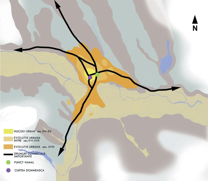
Iasi underwent a long process of urbanization, starting in the mid-14th century. In the 15th century, the town became an important craft, commercial and economic center, the nucleus of which seems to be located on the lower terrace of the Bahlui River, at the intersection of two trade roads (Fig.1).
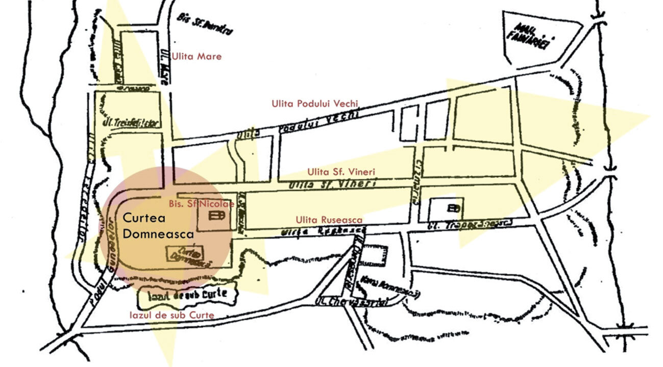
From the point of view of the street contour, a strategic importance of the city's origin is its position at the intersection of important trade roads, which favor trade. The Curtea Princiară in Iași is located southwest of the nucleus, a phenomenon that later led to an intensification of urbanization in this area. Thus, along the axis of the Princely Court, the Strada Mare (or Princely Street) appeared, the second axis of development oriented north-west (going as far as the Unirii Square), which would be occupied by the courts of the boyars, high dignitaries and nobility in general, but also by churches and shops, which "still "read" today, letting the medieval character appear (Fig. 2, Fig. 3).
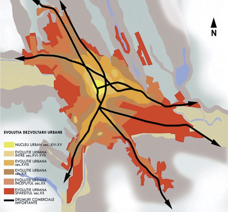
Once it became the capital, between the 16th and 17th centuries, Iasi quadrupled its surface area and became the largest city in Moldavia.
It is easy to notice the appearance of numerous new neighborhoods, especially in the north-west, north-east and east of the original nucleus. In addition, a crown of villages gravitates around the urban center (Fig.4).
An important modernization process takes place, not only in terms of architecture, but also in terms of the existing road network and urban structure. Strada Mare was significantly widened, but many manor houses and monastery enclosures did not survive the interventions. Moreover, new public spaces were created or multiplied in the urban fabric. It is worth mentioning the emergence of public gardens, with the destruction of the enclosure walls of the Princely Palace in 1841, on the site of the current Palace Square.
An important axis was also opened, giving rise to a "high-ranking" neighborhood (Copou neighborhood, along the present-day Carol I Boulevard) welcoming the Copou Garden, which remains unchanged to this day.
As a component element of the urban texture, the public square has played a secondary role over time. Thus, most of Iasi's markets appeared relatively late, with the "systematic" urbanization.
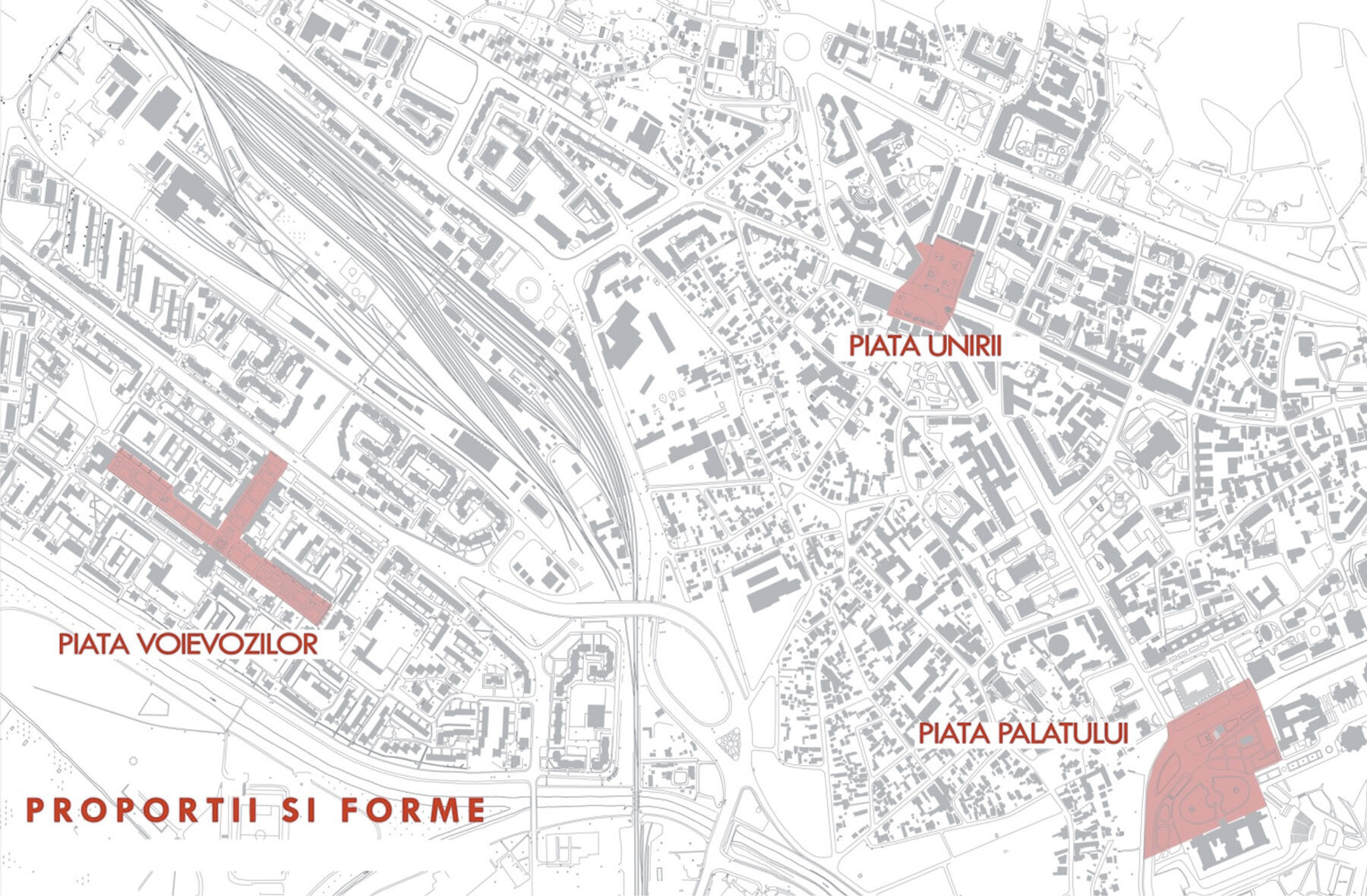
Markets with regular contours are characteristic for new neighborhoods, resulting from planned interventions (Voievozilor Square, the roundabouts along Grigore Ghica Alley in Copou neighborhood). That is why we have chosen three squares: Palatului, Unirii and Voievozilor, distinct in terms of their period of appearance, morphology and ambience (Fig. 5).
These are three places where life, in its complexity, with its qualities and difficult moments, makes its presence felt at every step. It is this complexity that makes these spaces both good and bad places to live, and it is this complexity that points to "genuine urban facts", because in order to find "character", we need to investigate places that are part of the city, culture and society, not in a superficial way (used because they are there), but that are assumed and integrated by this city, culture, society.
Case study
Appearance/Founding: Palace Square, Unirii Square, Voievozilor Square
Period / Years:1564 - The Princely Court of Moldavia moves to Iasi
1841 - demolition of the court walls and creation of the public square
Political regime: Principality of Moldavia
1896 - Mr. Mihail Sturdza - Kingdom of Small Romania (Moldova and Walla Wallachia)
1900 - King Carol I of Romania1930 - Socialism-Communism
1965 - Dictator Nicolae Ceausescu
Form / relationship to weaving: Spontaneous: transformation of the private space of the Princely Court into a public space
PRAG configuration: Spontaneous: natural evolution of the fabric - widening of part of the intersections
SOLID configuration: Planned - insertion in a large NEGATIVE AXIS
Function/practices/uses: Place of power Commercial function (numerous cafes, restaurants, coffee shops, terraces, etc.) Place of passage and promenade, meeting place, city scale Place of promenade, neighborhood scale
Palace Square
The oldest, after the appearance of the actual space (although it was not called a "square" at the time) is the Palace Square, dating back to the 16th century, when the Princely Court moved to Iași, the city becoming the capital of the Principality of Moldavia.
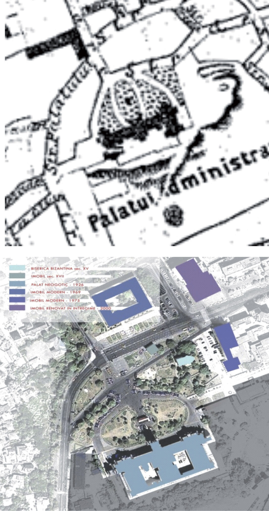
It was built on the best protected natural site, the promontory of the lower terrace of the Bahlui River, surrounded by water and with a guaranteed visual command of the surroundings. For the Palace Square, the space has changed enormously, particularly in terms of its architectural framework, since it was transformed into a public space in the mid-19th century.
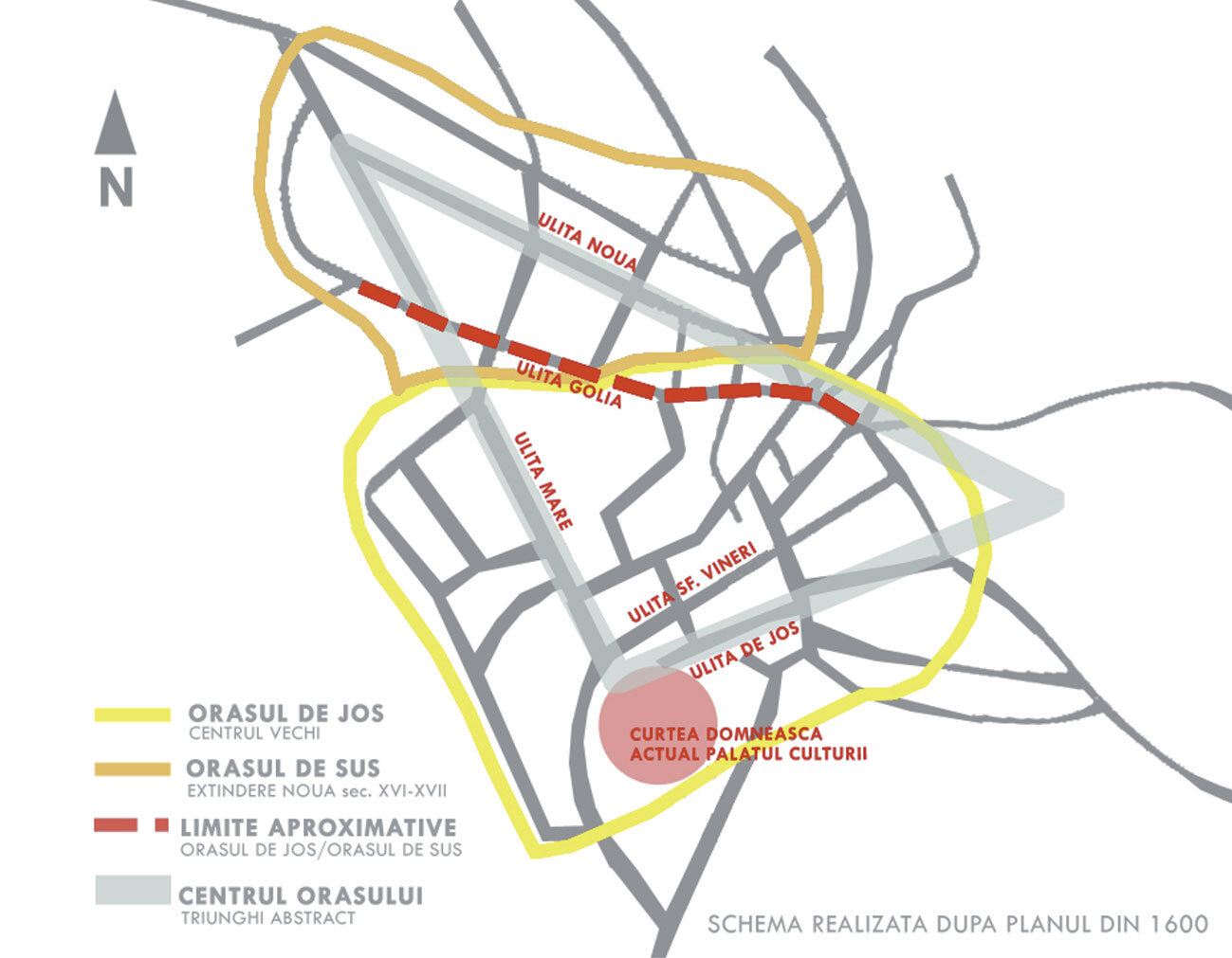
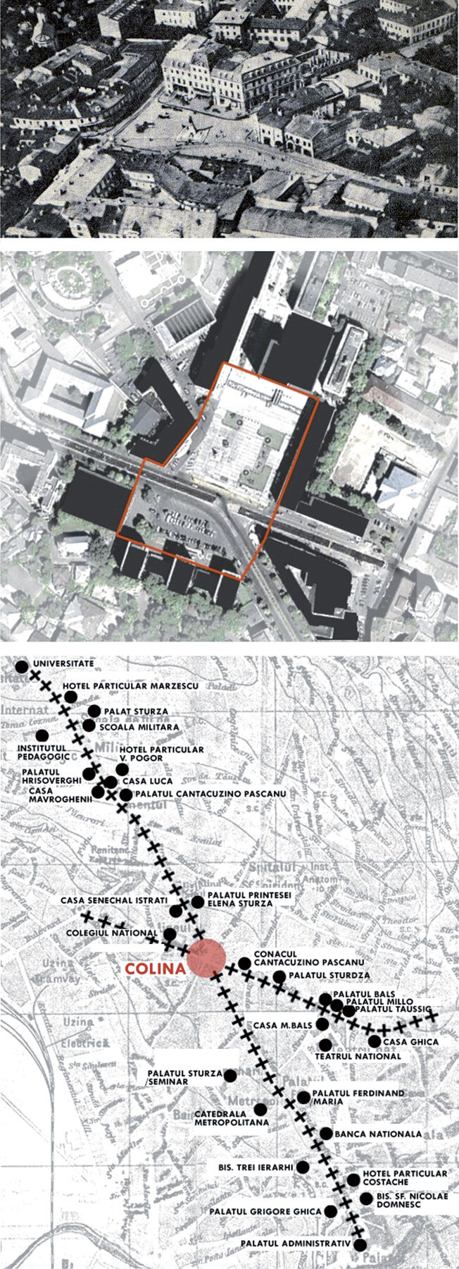
The only building that has remained unchanged from that period is the Dosoftei House (today the Museum of Romanian Literature), thus linking the main square with the commercial and industrial nucleus of the period, which retains its original structure. It should also be noted the appearance of the Ulița Mari, almost in the axis of the Domnești Court, which constituted one of the sides of the famous triangle in the city center: Ulița Mare (Bdul Ștefan cel Mare și Sfânt), Ulița de Jos (Grigore Ghica str.) and Ulița Nouă (Bdul Independenței), with the current Palace Square as its southern peak (Fig.6). Thus, Ulița Mare would be a positive axis: the boyars choose to settle here, leading to an increase in land value and a strong monumentalization. On this axis are grouped all the sophisticated houses and the most important religious buildings (Three Hierarchs Church, the White Church, later replaced by the Orthodox Metropolitan, etc.).
It is worth noticing that this axis is generated and maintained by the implant of the Domnesc Palace, which positively points the area, where endoregulated trajectories dominate.
In the meantime, behind the Palace, the idea of the extension of the positive axis is still topical. On the site occupied in the 20th century by the municipal swimming pools, an urban development complex is emerging, comprising business centers, residential areas, commerce, green spaces and leisure areas. In terms of urban structure, this project is (at least in theory) part of the type of reasoning characteristic of the positive axis, situated as an extension of the Stefan cel Mare Boulevard, reinforcing the configuration of the perimeter of the Palace Square. In this sense, it is certain that the Palace Square is the very cause of the emergence of Iasi. It is the cradle, the heart, the generating element. With this privileged position in the city's hierarchy, it represents the driving force of urban genesis (positive axis), applied to the commercial-artistan node (negative axis).
Union Square
"The unique and coquettish square, realized with great sacrifices by mayors Vasile Pogor, Nicolae Gane and Ioan Diamandi, for which expropriations were made to widen the previous intersection (....)" (Mitican, 2009) It has a strategic location in the urban fabric, being situated at the intersection between the boundary of the old city (marked by Golia Street) and the extension of the axis generated by Ulița Mare through Lăpușneanu Street and the Old Green Bridge (the current Carol I Boulevard), up to the top of Copou hill (Fig.7).
It is easy to notice that the axis represented by Golia Street was, in the 18th and 19th centuries, the cultural area of Iasi. As we rediscover it, this axis clearly appears as a positive end, valorized by numerous monumental constructions.
The intersection that preceded the square represents the spatialization of this abstract solid, which makes it possible to explain the appearance of the Union Square in this precise place and the influence it had on the development of the city.
According to the authorities, the square was to be a harmonious blend of past and present, with a 'contemporary look'. The whole effervescent pre-war atmosphere is replaced by a huge, cold void, with only the ground floors of the bar blocks containing large commercial spaces.
Architect Gheorghe Husar's scheme envisaged a third phase, which was never realized and was supposed to solve the area's traffic problems by creating an overpass.
The fact that the third phase was not realized still affects today the vital traffic links, in particular the north-south connection of the city and at the same time the spatial quality of the square, which is cut in two, with the pedestrian connection being made only by an underpass.
Voivodes Square
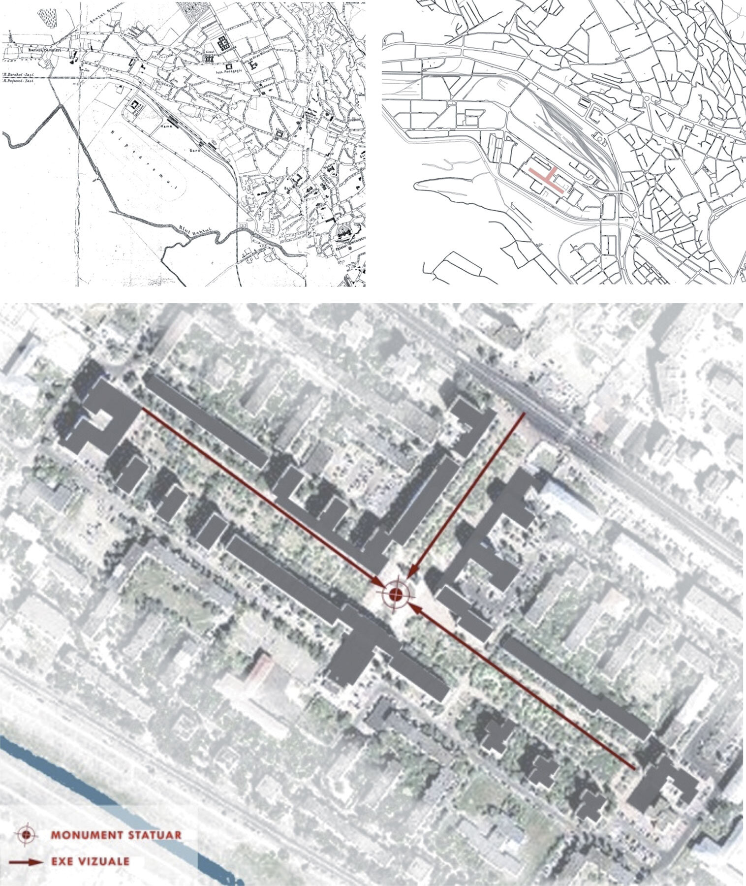
The third square of the study is much more recent (second half of the 20th century) and is part of a residential neighborhood designed in 1965 on the site of an old racecourse. Thus, the urban planning intervention that created this square is characteristic of the period of its construction and responds to the demands of the time, required by the communist regime.
Within a residential complex of towers and bars, the square clearly shows its design type (Fig 8). The spatial organization of the neighborhood is structured only by the existence of the open space of the square which functions as a unifying element.
These squares are not just the result of different eras, but correspond to different ways of building the city. On the one hand, the Palace Square is a private space won by the city and made public, while the Union Square is simply the result of the transformation of the urban fabric in line with the demands of a society that is taking on and assimilating cultural and mentality changes, while the Voivodes Square is a design projected on an empty piece of land. Thus, Palace Square and Union Square represent spontaneous processes of urban development, while Voivodes' Square is undoubtedly the result of the city's planned urbanism (Fig.9). Starting from the political context of the moment of the squares' constitution, their symbolic meaning changes. Thus, Palace Square is undoubtedly linked to the power of the Court, while Union Square, as its name indicates, owes its creation to a tumultuous political context. In contrast, the Voivodes' Square is the obvious mode of expression of the political ideologies of its era. As presented, the transformations undergone by the three squares over time illustrate the structuring character of these spaces for the entire urban organism. It is also easy to find a relationship between the change of political regime and the different modes of spatial intervention on public market spaces.
BIBLIOGRAPHY:
PAQUOT, Th. L'espace public, Paris, La Découverte, 2009;
CHOAY, F.; MERLIN, P. Dictionnaire de l'urbanisme et de l'aménagement, Parif, PUF, 2009;
CHOAY, F. L'Urbanisme, utopies et réalités, Paris, Seuil, 2006;
MERLIN, P. L'Urbanisme, Paris, Presses Universitaires de France, 2009;
ARENDT, H. Qu'est-ce que la politique, Paris, Seuil, 1995;
ARENDT, H. Le système totalitaire, Paris, Seuil, 2002;
ROSSI, A. L'architecture de la ville, Gollion, InFolio, 2001;
SITTE, C. L'art de bâtir les villes, Paris, Seuil, 2001.
*Andreea Grigorovschi is an architect-urban planner; assistant at ENSAS (Ecole Nationale Supérieure d'Architecture de Strasbourg); PhD student in architecture, urbanism and spatial planning at the Université de Strasbourg, France; researcher at the AMUP (Architecture Morphologie Urbaine et Projet) laboratory, ENSAS.
*Mircea Grigorovschi is lecturer dr. arh. at the Faculty of Architecture "G.M. Cantacuzino" of Iasi.