Revolution Square - traffic study
This article is made especially for this issue of the magazine and represents a traffic study explained in text and diagrams of the traffic flows in Revolution Square, Bucharest. The specific measurements were made in 2011. The study is prepared by traffic engineers Eugen Ionescu and Adrian Vîlcan.
In recent times, many urban planning specialists have been arguing about the "choking of urban life", while at the same time making significant progress in urban planning practice, both in terms of planning principles and traffic organization to create better conditions for pedestrians and for a dynamic urban life, giving less advantages to car traffic.
Analyses in several large cities have shown that more traffic arteries encourage an increase in car traffic, but improving conditions for pedestrians stimulates social (recreational) activities; accessibility to areas where various events take place, and thus, by default, increases the vitality of the city. Bucharest has developed over the course of its history and nowadays has a radial ring-shaped street network, with major arteries extending into the territory of influence with highways, national or other (county or municipal) roads. It falls into the category of large cities both in terms of surface area and population, in which a process of urban, economic and social restructuring has taken place over the last twenty years, with secondary effects such as an increase in the number of cars (especially passenger cars) and in mobility, as well as its diversification.
In addition to these two elements, the increase in the number of cars and mobility, there is also a shortage of parking spaces, which has an impact on pedestrian areas (pavements) and makes it difficult to travel on foot or by alternative means. The rule of thumb is that when a new street appears in the structure of a city's street network or the traffic capacity of an existing one is increased by re-profiling or one-way streets, it will attract traffic. This has happened in the case of a street that is representative in every respect, such as Calea Victoriei. This artery connects Victoriei Square and Splaiul Unirii, crossing Revolution Square.
The route of the Victoria Way is marked by representative buildings, both architecturally and functionally, that have appeared over time and that mark the history of this street, but also of the city, which is why it is necessary to create conditions that stimulate social and recreational activities - such as reducing car traffic.
To this end, the "Buzești Street" variant has been analyzed, which starts from the same starting point in Victoriei Square and has the same orientation.
Transformed into a category I artery (three lanes in each direction and a tram platform), the Buzești intersection will take most of the traffic currently on Calea Victoriei.
As has been pointed out, the realization of this artery faces some difficulties but, once completed, a series of measures can be taken to give Calea Victoriei a different status - that of an urban space given priority to pedestrians. This is why it is proposed for the sections of Victoriei Square - Revolution Square (Stirbei Voda Street) and the intersection of Ion Câmpineanu Street - Spaiul Unirii:
- re-profiling the Calea Victoriei artery with the roadway maintained at two traffic lanes;
- widening of the sidewalks up to the new limit of the roadway;
- aligning curbs at intersections to the new configuration;
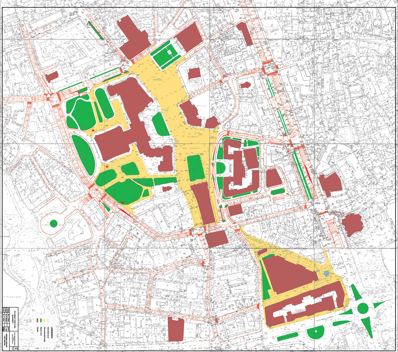
- closing the Revolution Square to car traffic, between the points marked by the intersection with Știrbei Vodă and Ion Câmpineanu streets, thus making this area strictly pedestrianized.
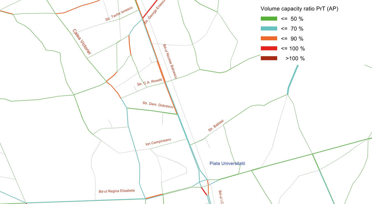
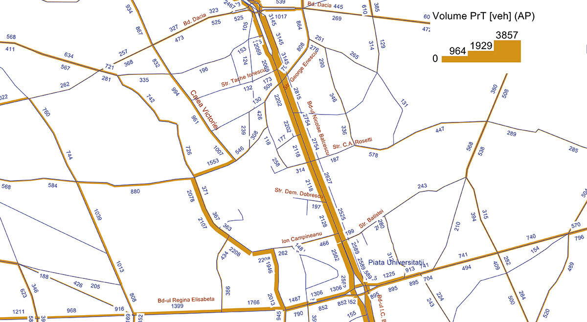
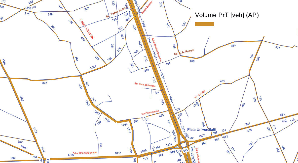
Figure 1 shows the traffic flows, expressed in vehicles/hour, for the afternoon peak hour, based on the Origin - Destination matrices calibrated for the base year 2011. The maximum flows on Calea Victoriei, between Știrbei Vodă and C. A. Rosetti, reach about 2,800 vehicles per hour, and before the intersection with Bdul Regina Elisabeta they reach 2,272 vehicles per hour.
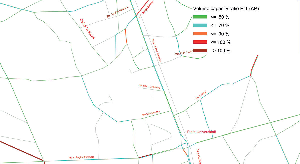
Figure 2 shows the Volume/Capacity ratio - which illustrates the degree of loading of the road network.
Under these conditions, access to the buildings that delimit Revolution Square will be pendular on the streets that start in Revolution Square or tangent on the east side (Academiei Street with connection to Dem. Dobrescu street, Ministry street and Boteanu street) according to the situation plan.
Regarding MAI, it is necessary to realize an underground parking lot with access (entrance/exit) from this tangent. In order to estimate the impact that the closure of the Revolution Square to vehicular traffic will have on the traffic distribution on the network of streets and the degree of their loading in relation to their traffic capacity, the phenomenon was simulated using a mathematical model on two scenarios:
a. The existing situation illustrated, both in terms of the traffic flow and the loading fence of the streets in the area;
b. The N-S diagonal (Buzești - Uranus) is not opened, Calea Victoriei and Ion Câmpineanu street are rerouted;
In the conditions in which car traffic is closed in Revolution Square, the route followed for those traveling on Calea Victoriei will be on Știrbei Voda - Ion Câmpinenu street, returning to Calea Victoriei, the route will be about 100 m longer.
With regard to public passenger transport, for the routes connecting the eastern and central areas of Bucharest, crossing Revolution Square, they will be on Ion Câmpineanu street, from the intersection of Știrbei Vodă and Luterană street. Thus, on Știrbei Vodă Street (the route between Calea Victoriei and Luterană Street), traffic will be one-way.
Having specified these elements related to the structure of the street network and the way traffic is organized, we present the degree of traffic load of the street network and the level of service (qualitative index given by the flow/capacity ratio) for the current situation and in the two scenarios.
To estimate the effects on traffic of the realization of the pedestrian area at Revolution Square, we used the urban transportation model for Bucharest for the afternoon rush hour, calibrated within the PIDU project for the base year 2011. The transportation planning software used is VISUM 12.01-00. The use of the transport model proves to be extremely useful as the effects of interventions in the network can be estimated and optimized in order to improve traffic performance.
The realization of the pedestrian area at Revolution Square and the underpass in the direction of C.A. Rosetti Street, in two situations, i.e. until the opening of Uranus Boulevard and afterwards, will have a beneficial effect in decongesting traffic. The values of the traffic flows in the current situation, at the 2011 level, elaborated on the basis of the calibration of the mobility demand using the transportation model for Bucharest (the mobility demand or the initial Origin - Destination matrixes, related to 2007, was calibrated using data from the traffic census carried out in 2011) are presented diagrammatically. (Figure 1)
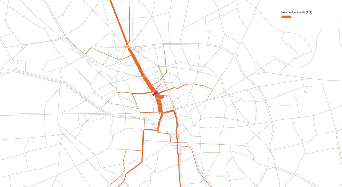
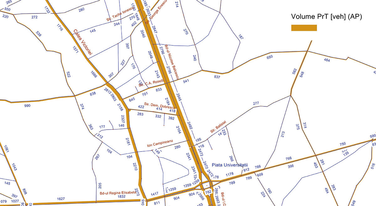
An analysis of the traffic flows on the sector with the heaviest traffic on Calea Victoriei, in the area of Revolution Square, shows their origin and destination and the routes they follow, as shown in Figure 3.
It can be seen that at the intersection with Bdul Regina Elisabeta the traffic flows are distributed, in relatively equal proportions, both on Calea Victoriei, further on, and on Bdul Elisabeta towards University Square.
Scenario 1
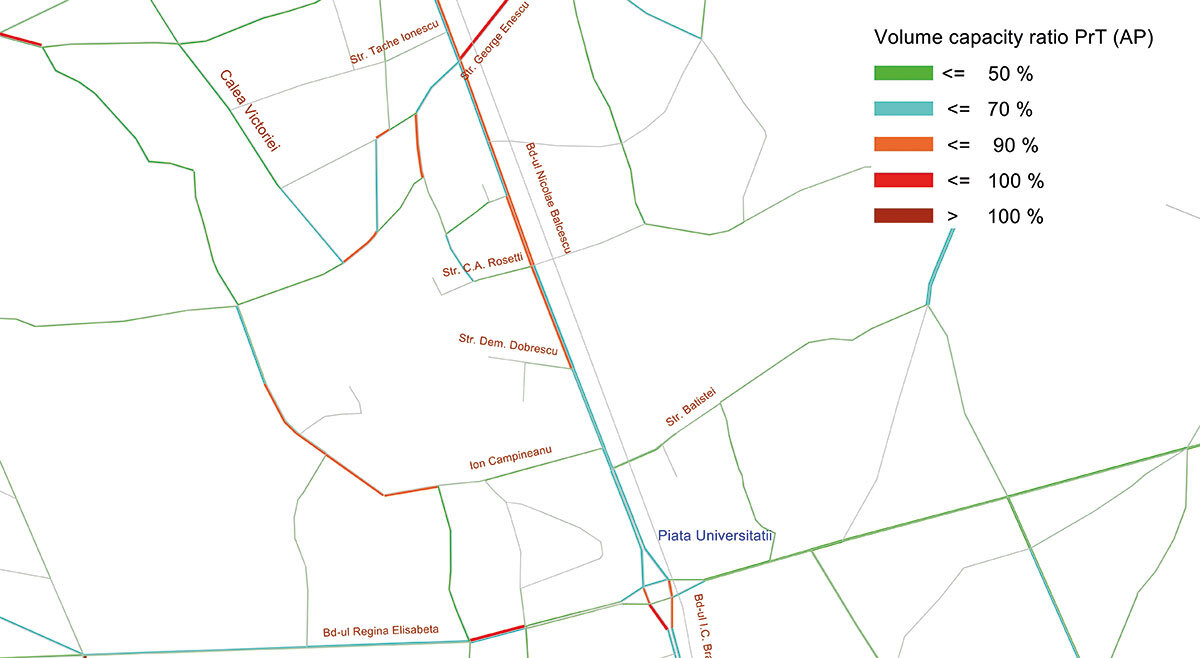
Figure 4 shows the traffic flows, expressed in vehicles/hour, for the afternoon peak hour, estimated for Scenario 1, with pedestrianized Piața Revoluției and without Bdul Buzești - Uranus. It is observed that the maximum flows on Calea Victoriei before Str. Știrbei Vodă reach about 1,000 vehicles per hour (about 670 vehicles per hour less than in the current situation), and before the intersection with Bdul Regina Elisabeta reach 2,013 vehicles per hour, about 260 vehicles per hour less than in the current situation.
Note that traffic flows on Episcopiei Street almost double the current situation, reaching 546 vehicles per hour, from 303 vehicles per hour in the current situation.
Figure 5 shows the Volume/Capacity ratio - which illustrates the degree of loading on the street network. It can be seen that the loading of the network at street segment level reaches about 90%.
Scenario 2
Figure 6 shows the traffic flows, expressed in vehicles/hour, for the afternoon peak hour, estimated for Scenario 2, with Piața Revoluției - pedestrian area and Bdul Buzești - Uranus. The maximum flows on Calea Victoriei before Str. Știrbei Vodă reach about 516 vehicles per hour (about 500 vehicles per hour less than in the previous scenario), and before the intersection with Bdul Regina Elisabeta reach 1,538 vehicles per hour, about 500 vehicles per hour less than in the previous scenario. Note that traffic flows on Episcopiei St., at 528 vehicles per hour, remain relatively constant compared to the previous scenario.
Figure 7 shows the Volume/Capacity ratio - which illustrates the degree of loading of the street network. The degree of loading of the network, at street segment level, improves substantially as a result of the opening of the Buzești - Uranus Boulevard.
Conclusions:
The proposal to close the Revolution Square to automobile traffic and to assign a strictly pedestrian status to the space between the intersection of Calea Victoriei - Știrbei Vodă Street and Calea Victoriei - Ion Câmpineanu Street requires a number of measures, such as the realization of the N-S crossing (Buzești - Uranus) and the reprofiling of the sections of Calea Victoriei and Ion Câmpineanu street, confirmed by the analysis of the effect of the implementation of these solutions on the traffic distribution on the street network and its degree of load, as presented in the considered scenarios.
- In Scenario 1, the traffic flows on Calea Victoriei are reduced by about 40% before Revolution Square and by about 10% before the intersection with Regina Elisabeta Boulevard, compared to the current situation. Str. Ion Câmpineanu, reconfigured to 3 lanes in each direction from Str. Știrbei Vodă towards Calea Victoriei and 2 lanes in the opposite direction, can handle the traffic flows in optimal conditions, with a capacity reserve of more than 10%.
- In scenario 2, when Buzești - Uranus Boulevard is considered as open to traffic, the traffic flows on Calea Victoriei are reduced by about 60% before Revolution Square and by about 30% before the intersection with Regina Elisabeta Boulevard, compared to the current situation. The capacity reserve of the street network in the area of Revolution Square increases significantly, by more than 30%.
We observe a considerable increase in the Volume/Capacity ratio on Calea Plevnei, between Bdul Regina Elisabeta and Bdul Buzești - Uranus.
- A detailed analysis would also be useful for the reconfiguration of intersections and traffic light cycles in the whole area adjacent to the Revolution Square, in order to ensure an optimal Level of Service at each intersection, thus minimum waiting times when crossing them.