The Discursive Relationship Between University City, UNAM, and Mexican Pre-Hispanic Cities
© Rodrigo Moctezuma González
In August 2024, I had the privilege of a journey that changed me profoundly — a journey into the heart of Mexico, to Mexico City, a place where the built environment carries the memory of thousands of years of history.
From the poetic modernism of Luis Barragán to the grandeur of Teotihuacan, this experience tied me forever to Mexican culture — a culture that, once encountered, is impossible not to fall in love with. For an architect, Mexico City is more than a destination; it is a living lesson in how space can transcend mere utility and become a vessel for emotion, a meeting place of the sacred and the profoundly human.
UNAM – A school the size of a city
The most unforgettable part of my journey was visiting the National Autonomous University of Mexico (UNAM).
The campus, a UNESCO World Heritage Site, is a city within the city — a living masterpiece of modernism woven into the cultural and natural fabric of Mexico. Built between 1949 and 1952 by an extraordinary team of Mexican architects — Juan O’Gorman, Mario Pani, Enrique del Moral — UNAM embodies the fusion of modernist ideals with a proud national identity.
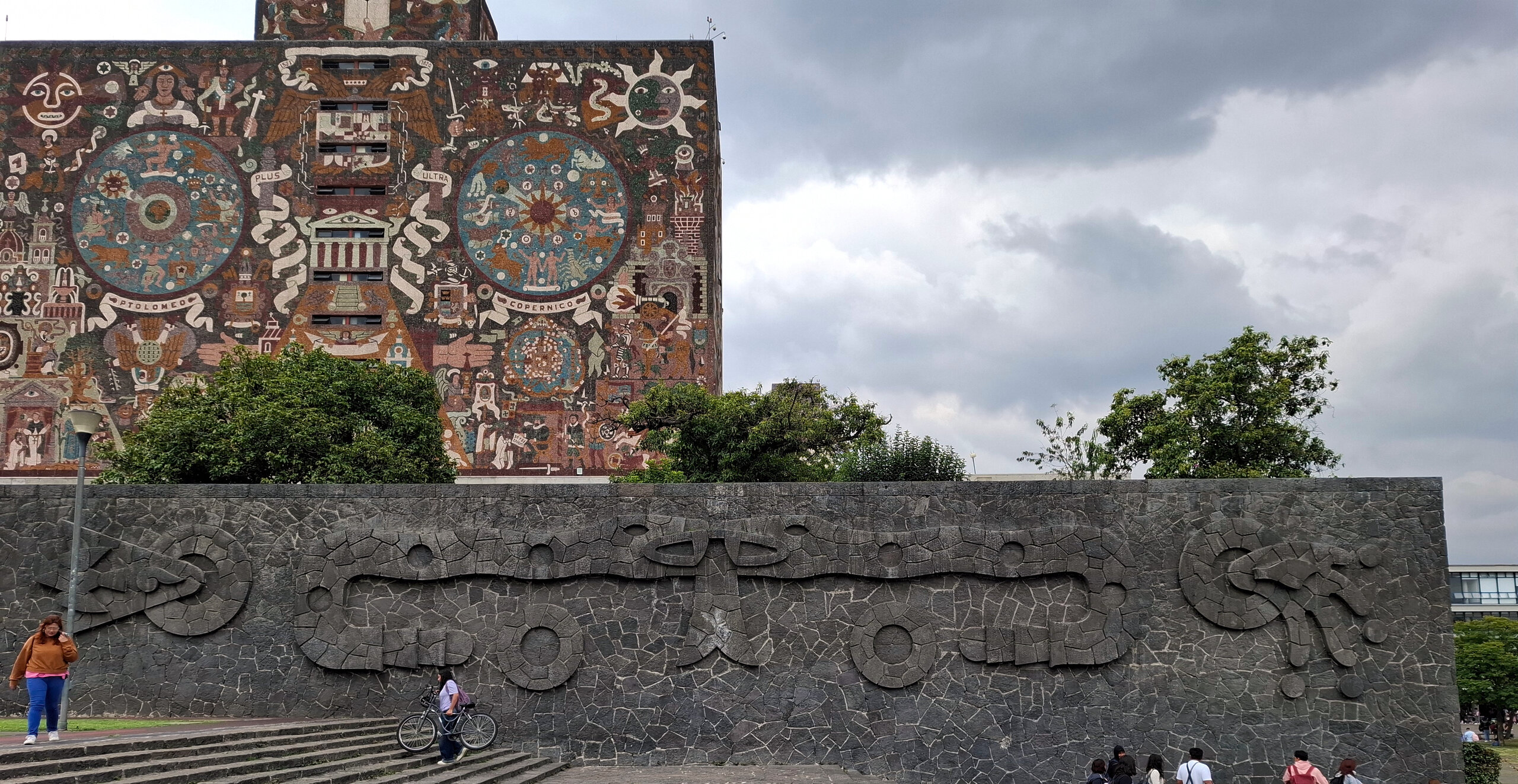
The Central Library stands at its heart, its monumental mosaic façade by Juan O’Gorman telling the story of a country: from Aztec mythology to the modern age. More than art, it is a narrative carved in stone and color, a chronicle that seems to speak to anyone who stands before it.
I was moved by the way architecture and art speak to each other here, transforming buildings into symbols that inspire generation after generation. At the Faculty of Architecture, we were welcomed with warmth and generosity. Professors and students spoke passionately about their work, their search for balance between tradition and innovation, and, to my delight, about their admiration for Romania.
As I walked across this campus — a city of ideas — I felt that architecture was not only a frame for education, but a participant in it, shaping the imagination and ideals of those who pass through it.
One of the highlights of my visit was a guided tour of the campus with Rodrigo Moctezuma, a gifted fifth-year student whose sketchbook and storytelling brought every mural and mosaic to life. His pride and knowledge left a lasting impression on me.
A year later, Rodrigo has written and illustrated a beautiful article about this campus — a story I am honored to share with you and warmly invite you to read.
Ioana Alexe
Editor-in-Chief
The Discursive Relationship Between University City, UNAM, and Mexican Pre-Hispanic Cities
Introduction
The National Autonomous University of Mexico (UNAM) is the largest educational institution in Mexico, with a population of more than 300,000 people, including students, professors, and maintenance and security staff. Additionally, it has multiple campuses across the country, as well as a presence in the United States, China, Spain, France, the United Kingdom, and Germany.
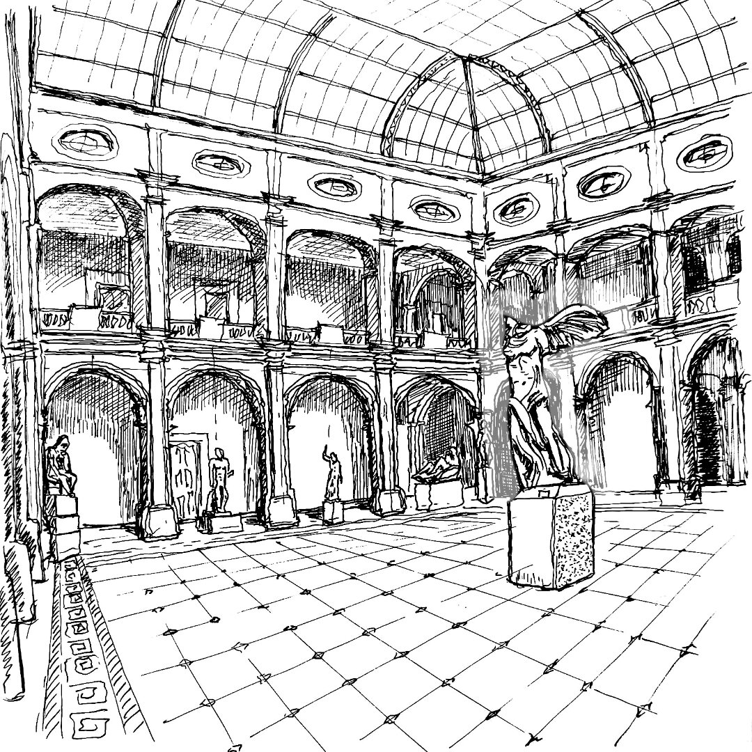
Until the first half of the 20th century, all UNAM faculties were located in downtown Mexico City, which provided a vibrant student life and constant activity that overlapped with other urban dynamics, such as commerce. By the third decade of the century, “it was evident that the teaching and research activities demanded by modern times could no longer be carried out in the old colonial buildings owned by the UNAM” (Lizárraga & López, 2014, p.21, author’s translation). Some of these buildings included the Academy of San Carlos for architecture and fine arts (Figure 1); the Palace of Mining for engineering and geology; the Palace of the Inquisition for medicine; and the School of Jurisprudence for law.
Both the need to decentralize the University and the possibility of bringing together all faculties and departments within a single campus gave rise to a new project of national scale in the 1940s, when a feasible location began to be considered for a new seat of higher learning in a University City (Ciudad Universitaria, C.U.). Several Latin American countries had already started to erect their own university campuses, such as Cuba in Havana (1901–1908), Colombia in Bogotá (1937), and the renowned campus of the Central University of Venezuela in Caracas (1945–1954) designed by architect Carlos Raúl Villanueva (Lizárraga & López, 2014).
The UNAM’s University City project began to take shape during the search for land, as by that time all of the Valley of Mexico had already become quite expensive and the plan was to acquire several hundred hectares. The most affordable area at the time was a volcanic lava field, the result of the eruption of the Xitle volcano (Figure 5) around 80 A.D., which buried the earliest pre-Hispanic culture of the Basin of Mexico —back then still a lake basin—known as Cuicuilco. It is worth noting that the main pyramid of Cuicuilco (Figure 4) was itself an allusion to the Xitle volcano, under whose lava it would later succumb. The eruption left a rocky terrain, ecologically and climatically different from the rest of the Valley of Mexico, today known as the Pedregal de San Ángel (Figure 2).
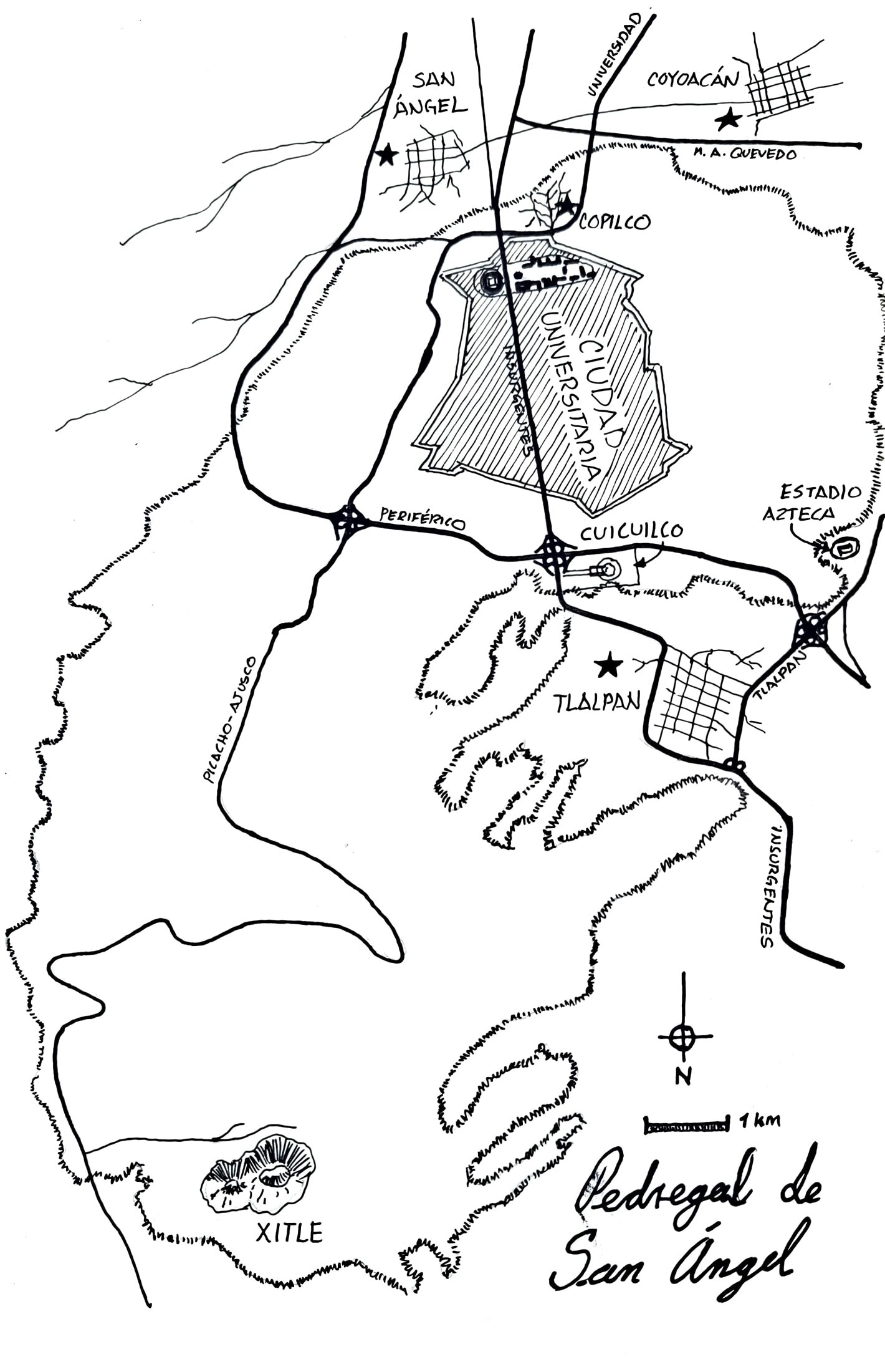
Figure 2: Pedregal de San Ángel’s area
© 2025 Rodrigo Moctezuma González
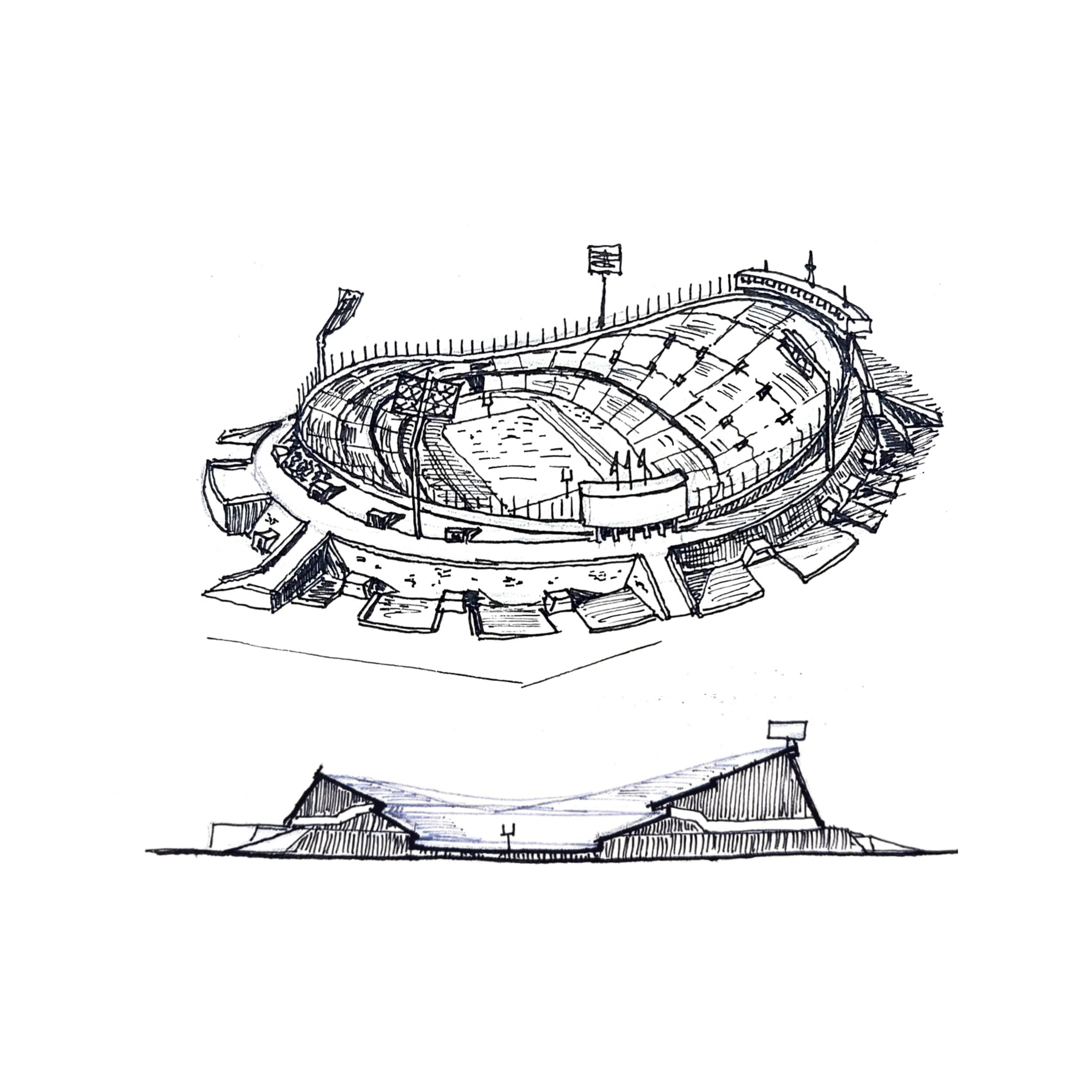
Figure 3: Olympic University Stadium
© 2024 Rodrigo Moctezuma González
For two millennia it was left unused by pre-Hispanic peoples, Spanish colonists, and Mexicans alike, due to its infertility and hardness. For this same reason, when the planning of C.U. began, the land was very inexpensive in the Pedregal, and the University was able to acquire 7.33 km² of these lands, of which 0.91 km² were relatively flat farmland, while the remainder consisted of basaltic flows (Pérez-Méndez, 2014).
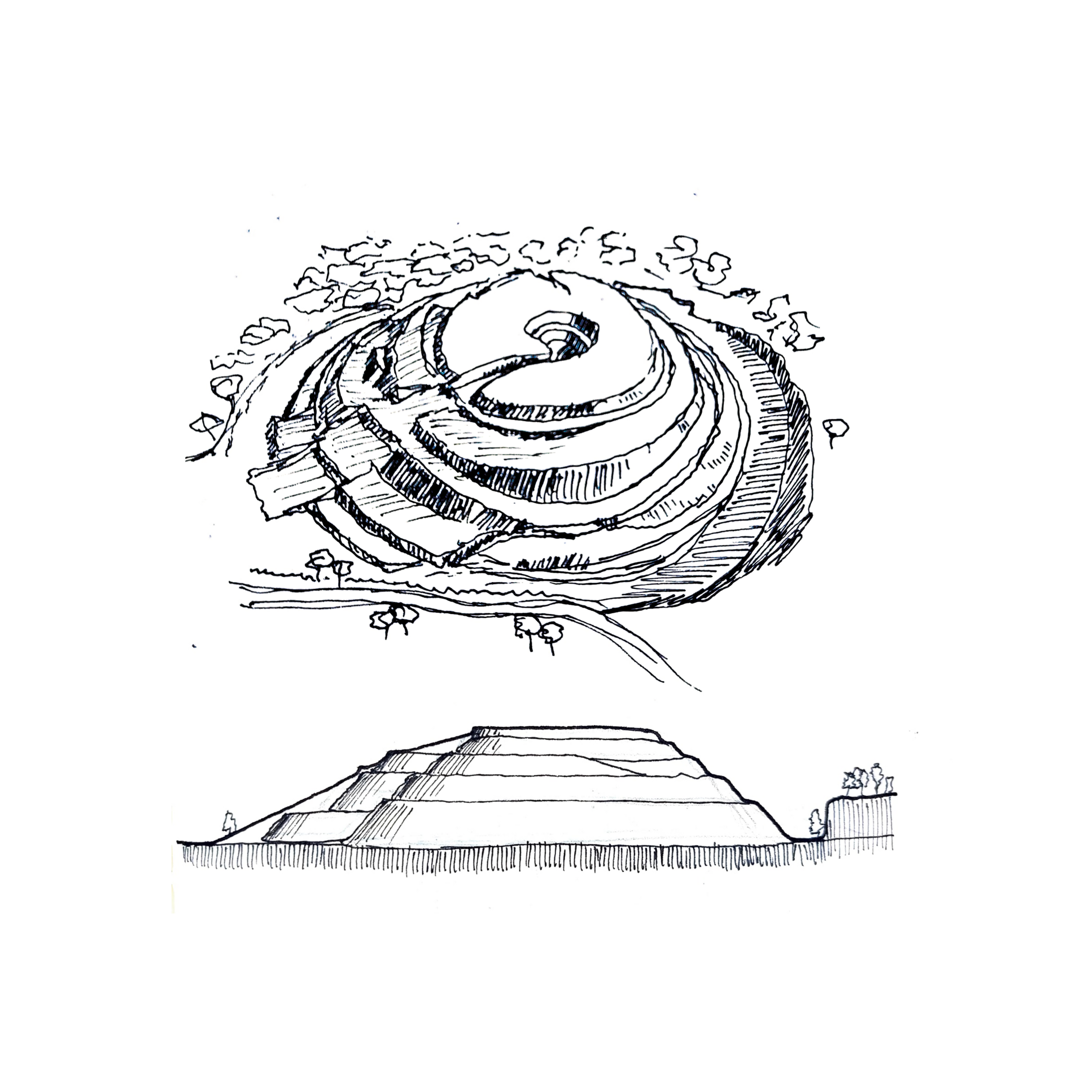
Figure 4: Pyramid of Cuicuilco
© 2024 Rodrigo Moctezuma González
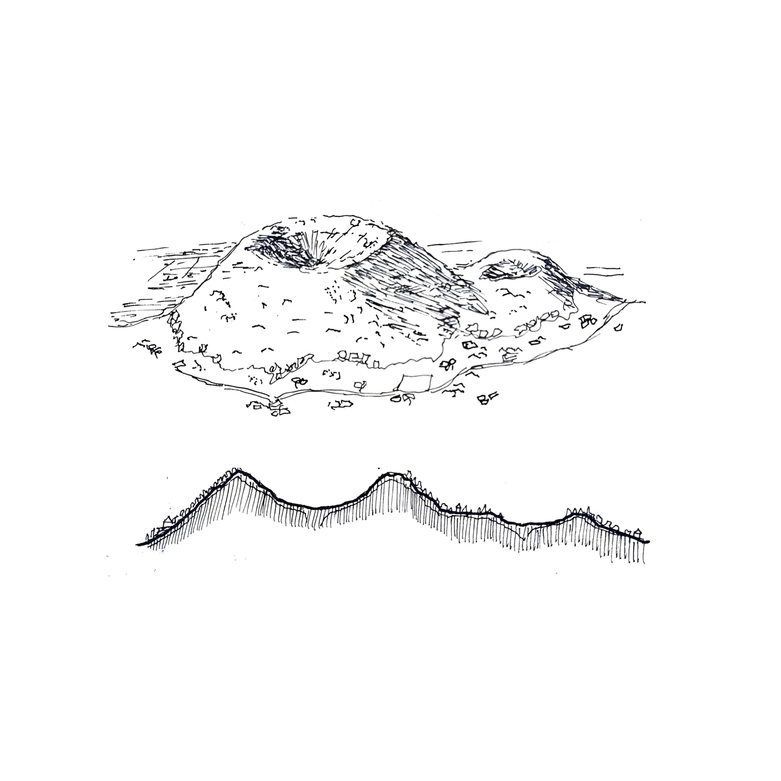
Figure 5: Xitle volcano
© 2024 Rodrigo Moctezuma González
Although the decisive factor in selecting the site of C.U. was the price of the land, following its acquisition in 1946 there was a meticulous effort to create a discourse justifying the decision to build the University City there, connecting it to Mexico’s Mesoamerican past and to the geographic prominence of the Pedregal de San Ángel throughout history. This narrative was mainly crafted by Carlos Lazo, who served as general manager of the architectural and urban planning project of C.U. It was necessary to legitimize the decision to establish C.U. so far from downtown Mexico City—14 km away—at a time when there was still no metro and other connections to the south were quite deficient. Around the same time, the residential development of Jardines del Pedregal, adjacent to C.U., was being built by architects Luis Barragán and Max Cetto, who sought to sell large plots for wealthy families to build houses while preserving the unique ecosystem in their gardens. Barragán made use of the officialist publicity of C.U. to promote his project.
University City and Pre-Hispanic Urbanism
Much speculation has arisen regarding the relationship between C.U. and the ancient Mexican pre-Hispanic cities. While there are unmistakable elements of Mesoamerican cultures—such as the reverse façade of the Central Library, which represents the pre-Hispanic pantheon, or the glyphs inscribed on the perimeter wall of its reading garden—other attributes appear to be more coincidental.
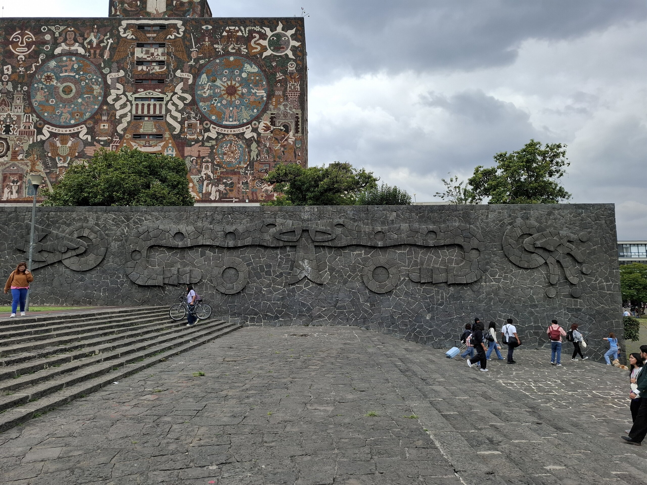
Figure 6: Central Library’s petroglyphs, southern façade
© 2025 Rodrigo Moctezuma González
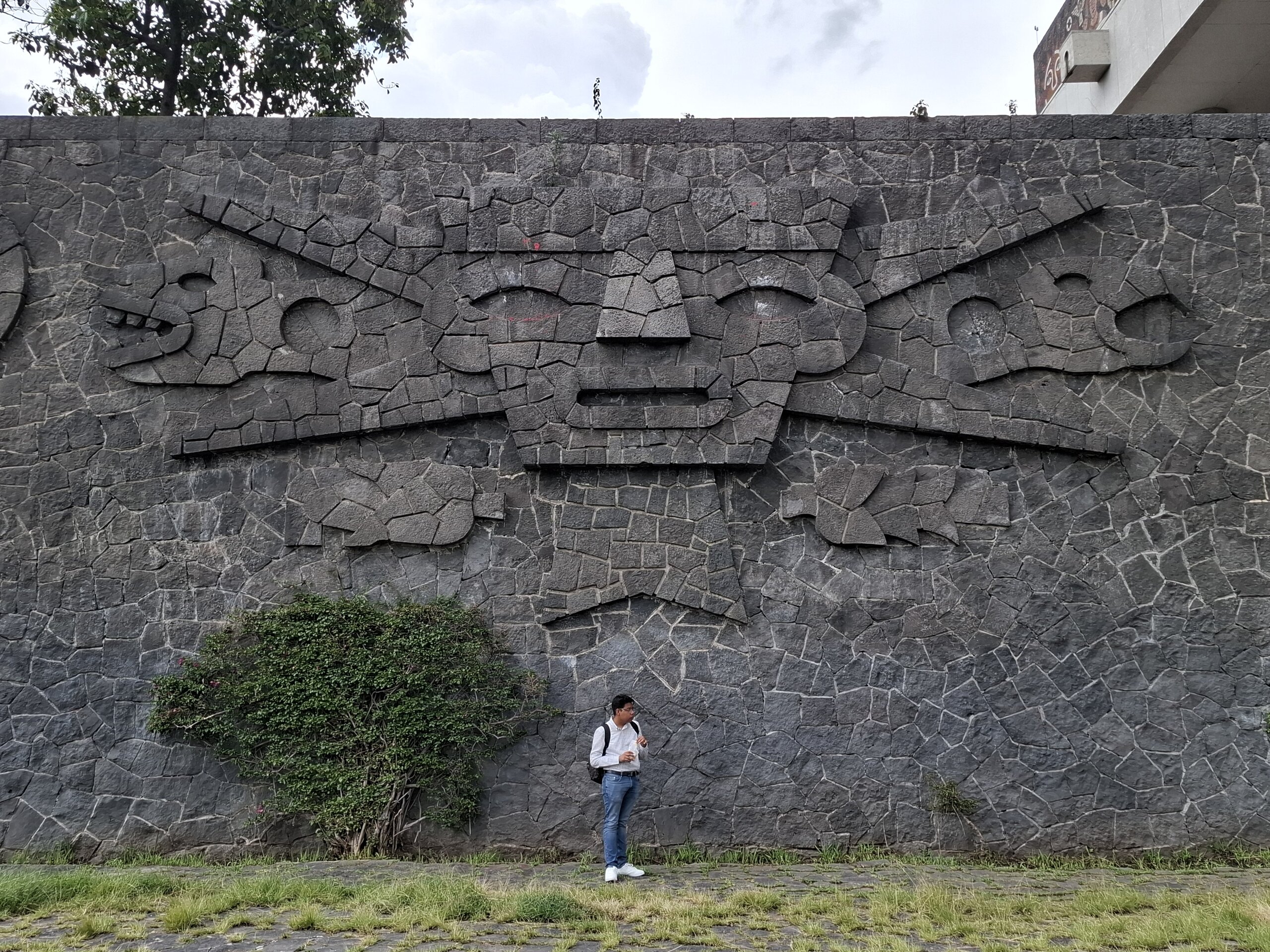
Figure 7: Central Library’s petroglyphs, eastern façade
© 2025 Rodrigo Moctezuma González
To begin with, the construction of the campus involved the extraction of enormous quantities of volcanic stone, which was used primarily in landscaping works such as stairways, plazas, retaining walls, and in some buildings. Considering that C.U. largely followed international functionalist canons of the time, volcanic stone became a distinctive feature of Mexican modern architecture, as evidenced in C.U., several of Barragán’s houses, and Diego Rivera’s Anahuacalli. Once most of the buildings were completed, Carlos Lazo decided to use all the leftover basalt to build the aforementioned landscaping works as well as the three-wall courts, calculated to withstand wind forces, resulting in sloped forms which “acquired shapes strongly identified with ancient indigenous constructions” (Miguel Alemán et al. in Pérez-Méndez, 2014, p.71, author’s translation). In Architectural Forum (1952), each court was compared to a truncated pyramid or an incomplete volcano. Moreover, as Villalobos points out (2014), they bear enormous resemblance to the yácatas of Michoacán, a type of pre-Hispanic pyramid belonging to the Purépecha culture.
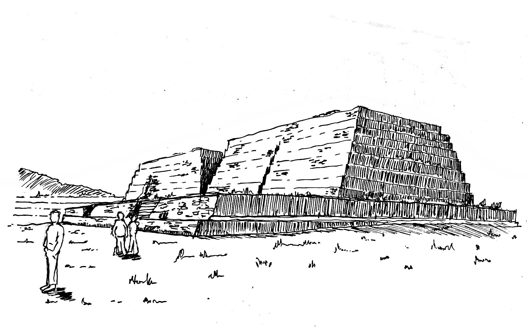
Figure 8: Yácatas of Michoacán
© 2025 Rodrigo Moctezuma González
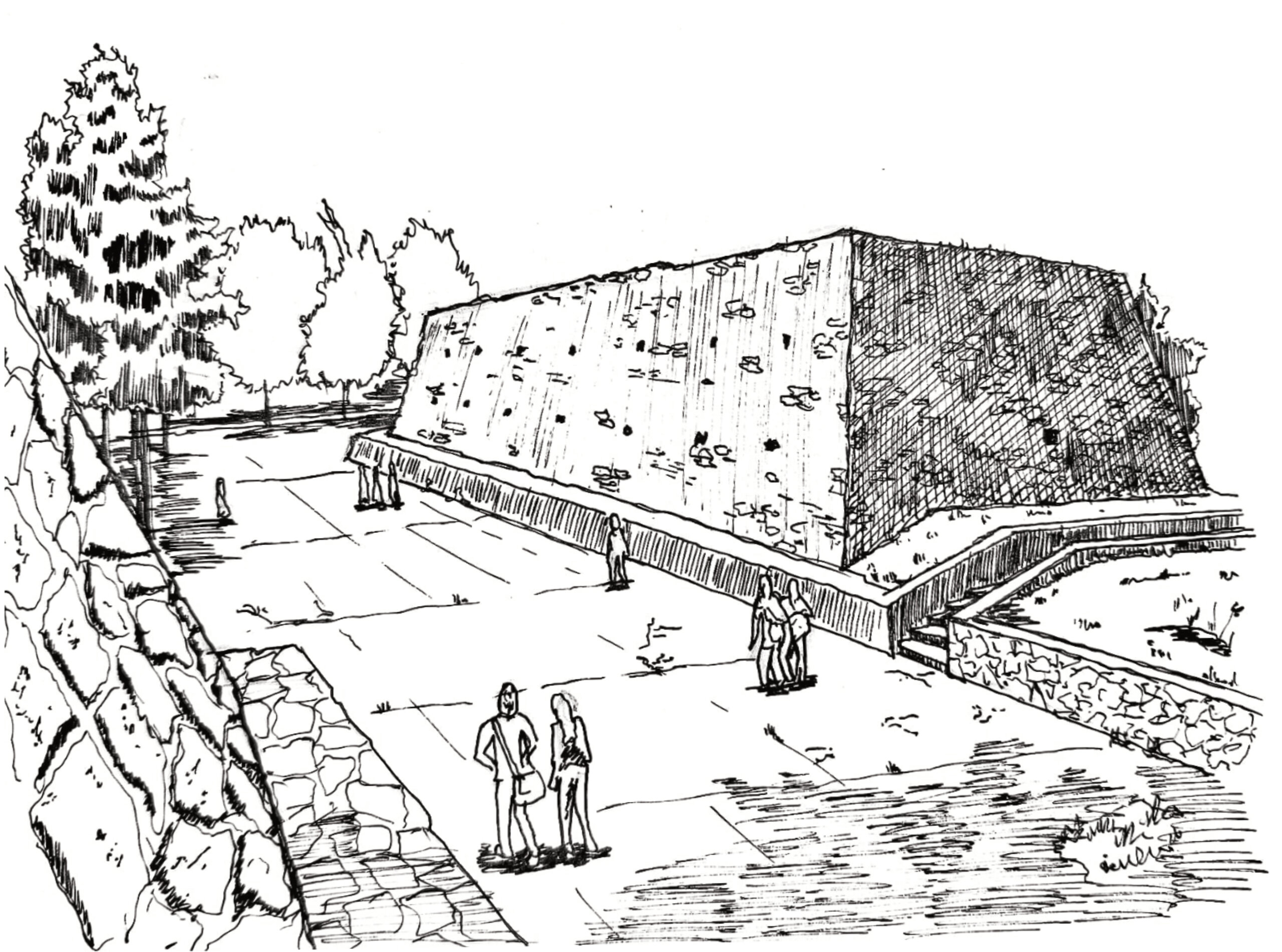
Figure 9: Three-walled courts of C.U
© 2025 Rodrigo Moctezuma González
The Olympic University Stadium, designed by architect Augusto Pérez Palacios, was conceived in direct relation to the origin of the Pedregal, and thus to the Xitle volcano and the pyramid of Cuicuilco. In Carlos Lazo’s words, “In reality what is being built here is a volcano” (Carlos Lazo in Pérez-Méndez, 2014, p.71, author’s translation). This ensured once again the use of on-site material, as the stadium was formed with embankments from the earth extracted during construction, later confined with basalt stone, which gave the stadium its distinctive volcanic aesthetics (Figure 3).
Paul Westheim, a German critic specializing in pre-Columbian cultures, was invited to visit the works of C.U. and compared in an article the “asymmetrical symmetry” of the campus with the Zapotec city of Monte Albán (Figure 12) (Pérez-Méndez, 2014). Additionally, Colombian writer Germán Arciniegas remarked that “a fortunate discovery has been made in the series of three-walled courts (Figure 9), which provide a backdrop to the sports fields by using the line of the pyramids in such a way that the visitor arrives as if to a new Teotihuacán” (Arciniegas, 1951, in Pérez-Méndez, 2014, p.72, author’s translation). Teotihuacán—spelled with or without an accent—is the most visited archaeological site in Mexico (Figure 10).
Markers of Hierarchy
Among the distinctive urban features typical of pre-Hispanic cities, three hierarchical markers in particular are worth noting, present in the vast majority of them. These can also be read in the urban configuration of C.U. and are the following (Figures 11, 12, and 13):
- Compositional axes or centrality: Clearly defined axes within monumental zones. The relationship of main buildings to these axes largely determined their importance, whether by alignment or by centrality.
- Platform level: The level from which a building or complex is raised. Platforms served as retaining walls and delimitations of urban space, corresponding to the topography and ensuring that the most relevant spaces were located at higher levels than the rest of the city.
- Building height: In addition to being built on higher ground, the main buildings were usually the tallest. While in many pre-Hispanic cities volume was prioritized over height—outside regions such as the Petén—, height nonetheless remained essential in most cases.
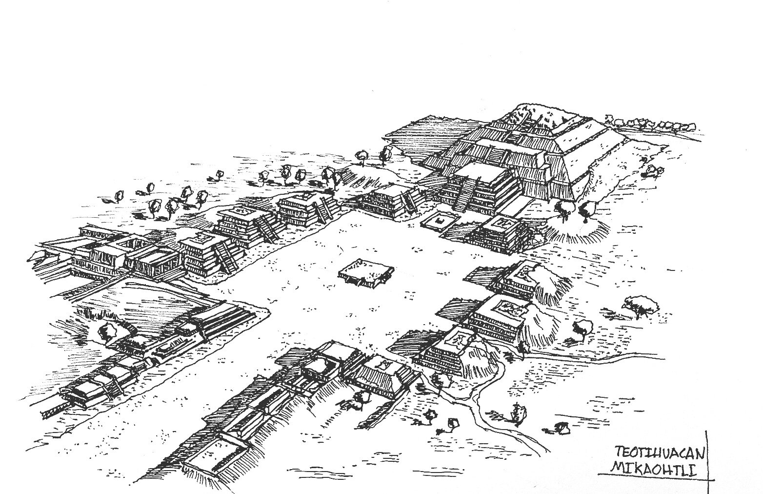
Figure 10: Teotihuacan
© 2024 Rodrigo Moctezuma González
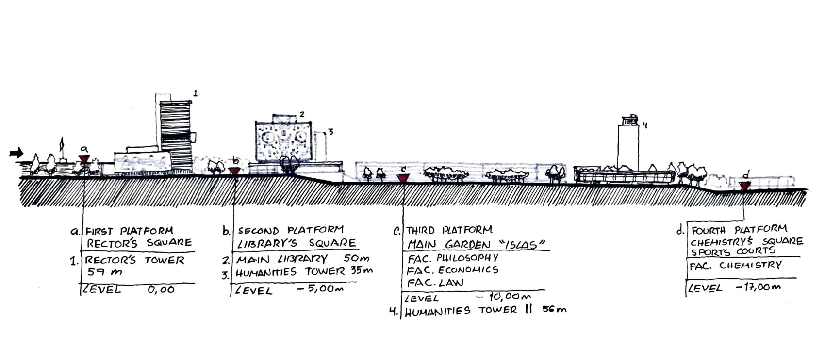
Figure 11: Section of University City, markers of hierarchy 2 y 3: platform height and building height.
© 2025 Rodrigo Moctezuma González
As indicated in the second hierarchical marker, in pre-Hispanic cities, the elevation of a building—established through platforms and retaining structures—also implied its urban relevance. This can also be observed in C.U. (Figure 11), where the natural topography of the land, with a total slope of around 17 meters, was used to situate the most important buildings on the upper platforms. The highest elevation was that of the Rectoría Plaza, topped by the most important building of C.U., the Rectoría Tower.
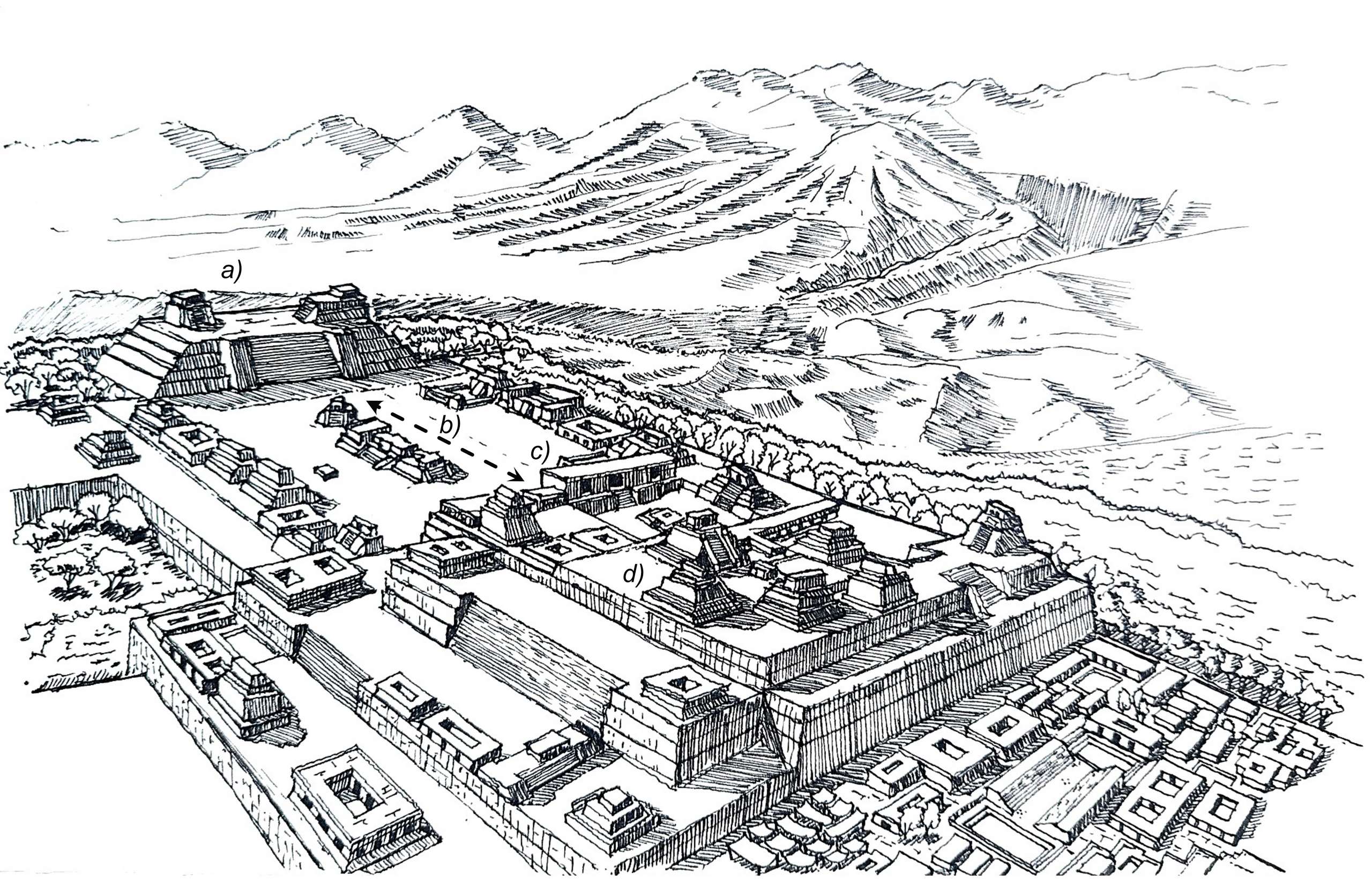
Figure 12: Monte Albán, Oaxaca. Markers of hierarchy: a) South Platform, serving as the visual culmination of the ceremonial center (compositional axis), being the highest platform and featuring a wide stairway, 45 m. On this platform stands Building III, which is the tallest, thus combining the three markers of hierarchy in a single complex; b) Main Compositional Axis; c) North Platform; d) Vértice Geodésico compound.
© 2024 Rodrigo Moctezuma González
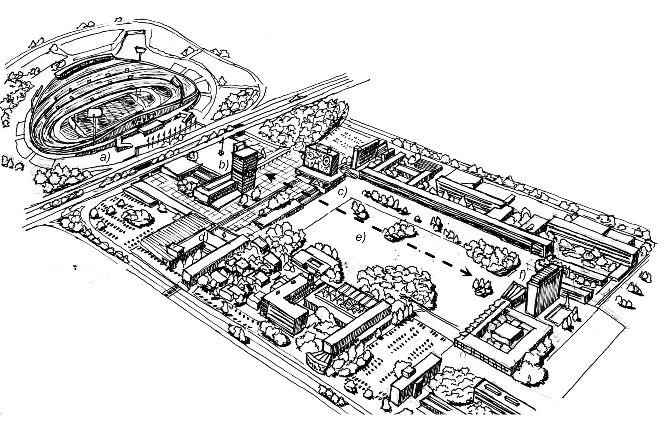
Figure 13: University City. Markers of Hierarchy: a) Olympic University Stadium, visual culmination of the main axis; b) Rectoría Tower, the tallest at 57 meters, standing on the upper platform and serving as the central building of the entire complex; c) Central Library, 50 m, culmination of the secondary axis; d) Faculty of Architecture, opposite culmination of the secondary axis; e) Main Compositional Axis of C.U. (east–west); f) Humanities Tower II, originally the Sciences Tower, 56 m, visual culmination of the main axis opposite the stadium.
© 2025 Rodrigo Moctezuma González
Final Thoughts
There is no conclusive evidence that the urban design of University City was directly based on pre-Hispanic compositional principles; rather, such comparisons seem to have been drawn retrospectively to legitimize the immense project. Nonetheless, its similarities with pre-Hispanic cities such as Monte Albán and Teotihuacán in terms of compositional axes, or Xochicalco, Teotenango, and Cantona in terms of platform hierarchies, cannot be ignored. As Villalobos (2014) notes, however, many of these sites were not restored and studied until the 1960s—at least a decade after the urban conception of C.U.—so their distinctive layouts would not have been widely legible at the time.
Specialists argue that the plastic motifs present in murals and sculpture, which undoubtedly draw inspiration from pre-Hispanic cultures and the Colonial Era in Mexico, are conceptually unrelated to the urban layout of C.U., which responds solely to the precepts of modern architecture of the time. Yet, given the context in which the University City project was conceived—marked by a renewed search for national identity or mexicanity—and contemporaneous with important publications such as Arquitectura Prehispánica (1951) by Ignacio Marquina, a prominent Mexican archaeologist and architect, it is plausible to consider that such ideas may have left an imprint on the imagination of the architects and planners responsible for the project. The absence—thus far—of conclusive evidence does not exclude the possibility that these similarities were intentional rather than coincidental. All things considered, University City is an unparalleled site within Mexico City and, regardless of the narrative, its architecture and urban planning will continue to surprise the generations that walk through it. The matter remains open for readers to draw their own conclusions.
Bibliographic Sources
- Lizárraga Sánchez, S. & López Uribe. C., (2014), Introducción, en Habitar CU 60 años, pp.19-33, UNAM, México D.F.
- Pérez-Méndez, A., (2014), Conceptualización de la ocupación del Pedregal, en Habitar CU 60 años, pp-37-83, UNAM, México D.F.
- Larrucea Garritz, A., (2014), La construcción cultural del paisaje del Pedregal de San Ángel, en Habitar CU 60 años, pp.85-91, UNAM, México D.F.
- Drago Quaglia, E. & Torre Rojas, J., (2014), Ideales para una ciudad universitaria, en Habitar CU 60 años, pp.95-131, UNAM, México D.F.
- Villalobos Pérez, A., (2014), El México antiguo como atributo imaginario de la Ciudad Universitaria de México, en Habitar CU 60 años, pp.245-257, UNAM, México D.F.
- López de Juambelz, R., & Cabeza Pérez, A., (2014), Ciudad Universitaria, un paisaje con identidad, en Habitar CU 60 años, pp.291-305, UNAM, México D.F.