70-300

The present text attempts to give a broad presentation of one of the early Bucharest's land-plotting realized in the first decade of the last century, on the outskirts of the then city, near Kiseleff Garden, on the lands of the Filipescu family. Unpublished archival information requires the presentation of a general historical framework referring to the area in the immediate vicinity.
Even a passing mention of the situation around the Mogoșoaiei Barrier, as it emerges from legal and graphic documents drawn up in the mid-19th century, brings into question a specific image of Bucharest at that time, in which the concerns of the commune administration for the 'beautification' of the city can be glimpsed. The realization of the public garden at the initiative of General Kiseleff is an important step in defining the character of the area, while also setting a standard to which future interventions will be based. The commune's attempts to create a representative nucleus for the city materialized in large-scale projects that called into question the configuration of a large square, the layout of "boulevards", and the realization of solid constructions in accordance with the new urban and architectural principles that Bucharest society was beginning to understand. In defining these objectives, for more than half a century, the responsible parties have been approving projects through which the peripheral area of the Mogoșoaiei barrier, with its market, dusty roads and reed-covered houses, will become one of the most appreciated areas of the city.
1. Historical context
The area at the "head of the Mogoșoaiei Bridge" was constantly influenced by the administrative perimeter of the city, a statement that is particularly valid after the adoption of the Organic Regulations, when clear boundaries were established and city barriers were positioned. By setting checkpoints on the important roads that connected the capital with the neighboring territories, the authorities tried to regulate the access of goods and to control more strictly who entered and left the city.
Such a point was located where the Mogoșoaiei Bridge ended and the road to Brașov began, in one of the most active areas of the city, given the importance of the road and the fair held there since 1787. The emergence of the commercial nucleus was due to Nicolae Mavrogheni1 who wished to benefit the mahalagiagi and the producers, while supplementing the income of his church - Izvorul Tă-măduirii - located nearby. The presence of the fair, which was frequented by farmers, craftsmen, small-scale producers in the handicraft industry (rudari, potters, boilermakers, etc.), led to the emergence of warehouses, taverns and inns2, which brought together a large crowd of people from the most diverse social categories every Thursday of the week3.
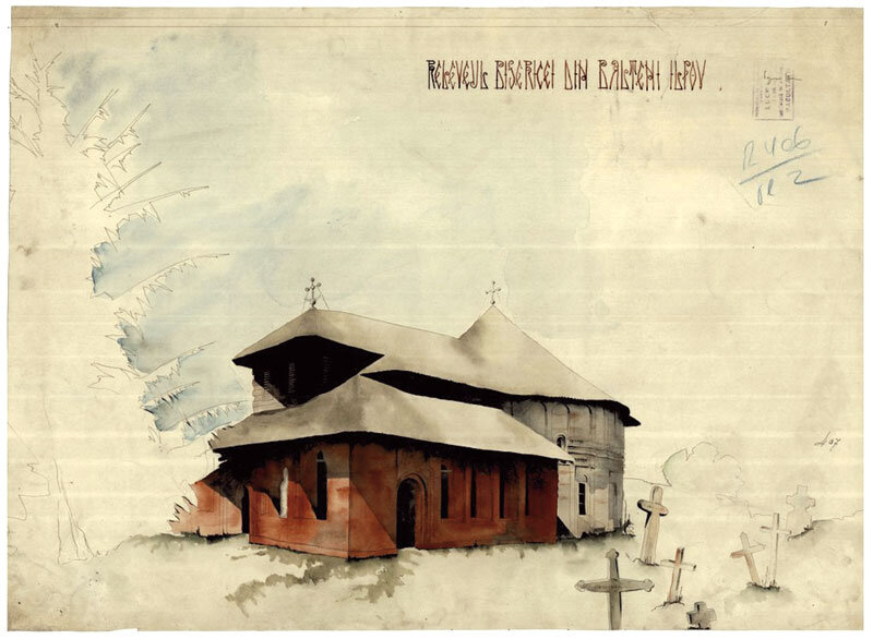
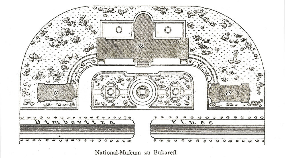
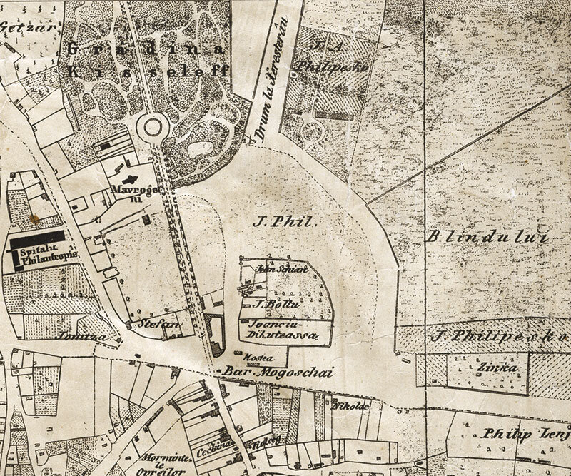
The regulatory period also called for the creation of "Jewish-style" gardens for the "preum-blarea" of the townsfolk. One of them will be made "At the head of the Podu-lui Mogoșoaia, in the place where the garden of the Chioșcului Ma-vrogheni used to be"4. The new garden, beautifully laid out and maintained by the authorities, soon became much sought after by the citizens of Bucharest. The character of the area was changing, so that the motley world of the fair, with traders and producers of all kinds, would give way to a world that appreciated strolling or walking5. Along the same lines of systematization of the area, ambitious urban operations are proposed, including the creation of a square "suitable for any gathering"6 and the opening of a 50-square-metre wide boulevard around the town. The old buildings, "which, however one looks at them, are found to be unsightly"7, no longer correspond to their declared intentions, so that their owners and occupiers are forced to give them up, leaving "the place unoccupied"8 [Fig. 1].
A significant case for this situation is the case of the lord Ioan Alexandru Filipescu, a person with a strong social status, who asked for permission in 1853 to build two-storey houses and a brandy cellar on the sites he owned with the embebatic of the Monastery of St.Sava9. Strict setbacks and alignments are imposed, possible building materials are specified, and in the case of the brandy distillery, the town architect points out "the inconvenience of having a brewery next to the public garden"10, making it impossible to realize. The difficulties encountered or perhaps the desire to realize a representative public market for the town near its garden finally led Ioan Alexandru Filipescu to give up his projects and to give the municipality, without financial claims, the land he owned with the embatic11.
Topographical representations made in the second half of the 19th century provide additional information about the land east of the Kiseleff Road. A first example is the 1856 plan by the Austrian officer Friedrich Jung, which shows a very wide road heading north-east towards Herăstrău - another place of entertainment for the people of Bucharest. Towards the east, large properties are marked, two of which, belonging to the Cantacuzino and Filipescu families, stand out for their gardens, which competed with the public gardens.
The plans drawn up by Major Pappasoglu in the 1870s12 of the same century call ȘoseauaNouă13 the road to Herăstrău, a name it would bear until 1900, when the plan drawn up by the Army Geographical Institute between 1895-1899 included the name Șoseaua Jianu. It was named after Ion Jianu, nicknamed Cănuț, who had his property at the beginning of the road14, and in front of it there was a well with a wheel and a stone cross called "Jianu's"15. The road was not unlike a country road, full of dust in the summer months and mud when it rained excessively. In this respect, we can quote Henri Stahl who, in his book Bucureștii ce se duc, noted: "The road is wretchedly primitive: unpaved, with deep ditches on both sides, full of potholes, with dust as big as two palms..."16. With the adoption of the City Boundary Law in 1895, coupled with urban operations involving the laying out of new boulevards, the Jianu Road attracted the attention of the authorities. In less than two decades, the image of the dusty road changed, its place being taken by a wide boulevard, supported by planting, paved with stone and lit at night.
A first alignment plan approved by the City Council in March 190217provided for a constant width of 24 m for the street, and 10 years later a new alignment of 82 m was approved. This consistent profile of the street supports the idea of building a National Park on the former Herăstrău estate, an intention materialized by laws passed in 1910, 1912 and 1913.
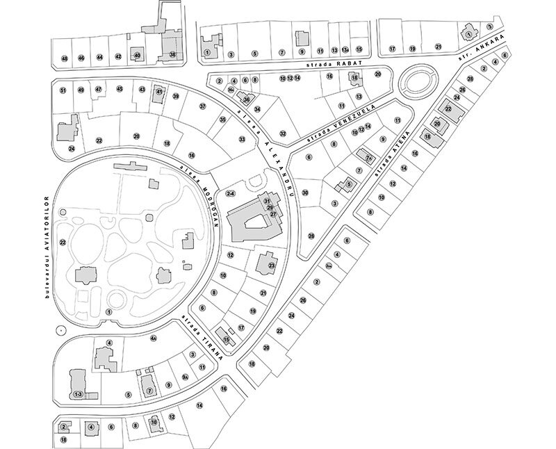
The land between Bonaparte Road, Jianu Road and Herăstrău Road (the future Prelungirea Dorobanților), which soon became part of the commune's administration, was dominated by large areas where agricultural and industrial activities were carried out. The plan drawn up between 1895 and 1899 depicts the Stancovici Mill, the Rope Factory, Cerchezi 's Brick Factory , land cultivated with vines, as well as the Minculescu and Filipescu residences, characterized by vast landscaped gardens. The only streets inside the island are those of the newly inaugurated Blank subdivision (Alley Blank A and B), the future Paris Street, with a rectilinear route that will later be extended to the Victoriei Square, and several access alleys to larger properties.
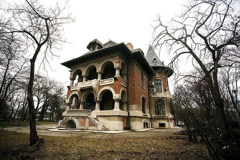
In a short period of time, the urban structure of the island under analysis changed its characteristics substantially, favored by the presence of large estates and the adoption of laws offering incentives to those who invested in the construction of housing. In less than four decades, almost the entire territory was subdivided by various investors - either private individuals or institutions. In 1912, the Elisei Filipescu estate was subdivided, and a year later Josse Allard and Baelde obtained approval for the Bonaparte Park. Then, one after the other, the parcels of the Society for the Construction of Cheap Housing (1916), the "Edilitatea" Society (1922), Mornard and Teodorescu (1922), Mornard and A. Hubert (1928), the "Moara" Society (1935) and the Mechanical Weaving Mill Society (in two stages, 1935 and 1940) were completed. Each of the 10 parcels has different characteristics, the result of the intentions of the investors and the technical committees. There are plots which, by virtue of their surface area, occupation, position in relation to the alignment or height, are aimed at social categories with obvious financial means (the case of the Filipescu and Bonaparte plots) and others (the plots of the Society for the Construction of Low-Cost Housing, the "Edilitatea" or "Moara" or "Moara" and "Țesătoria Mecanică") intended for a middle class made up of self-employed professionals, civil servants or employees of private companies.
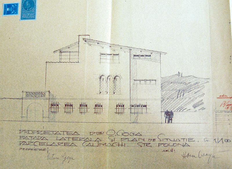
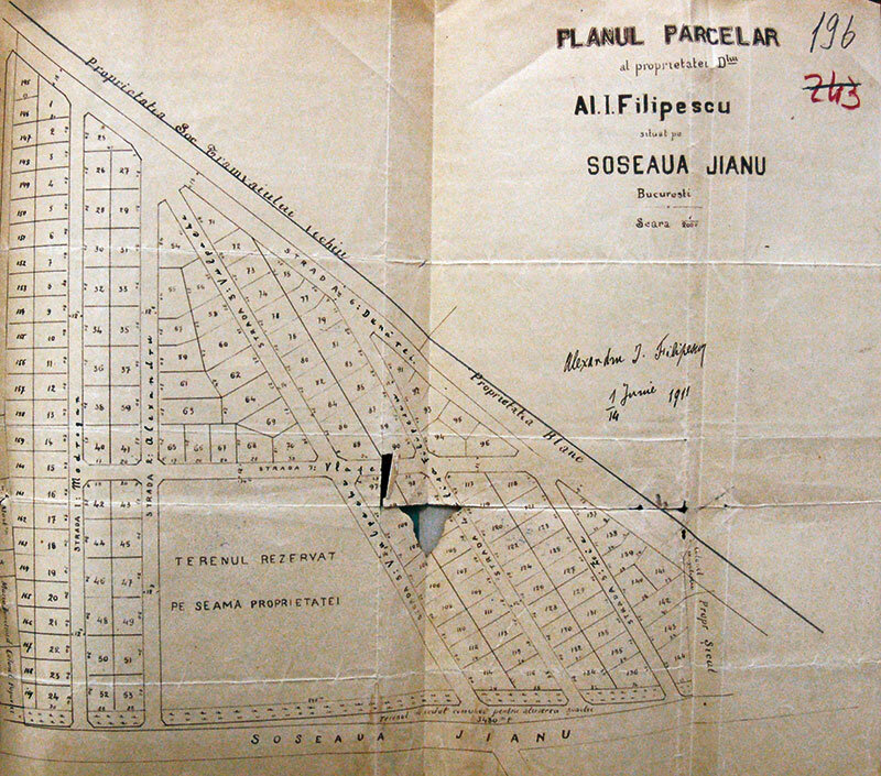
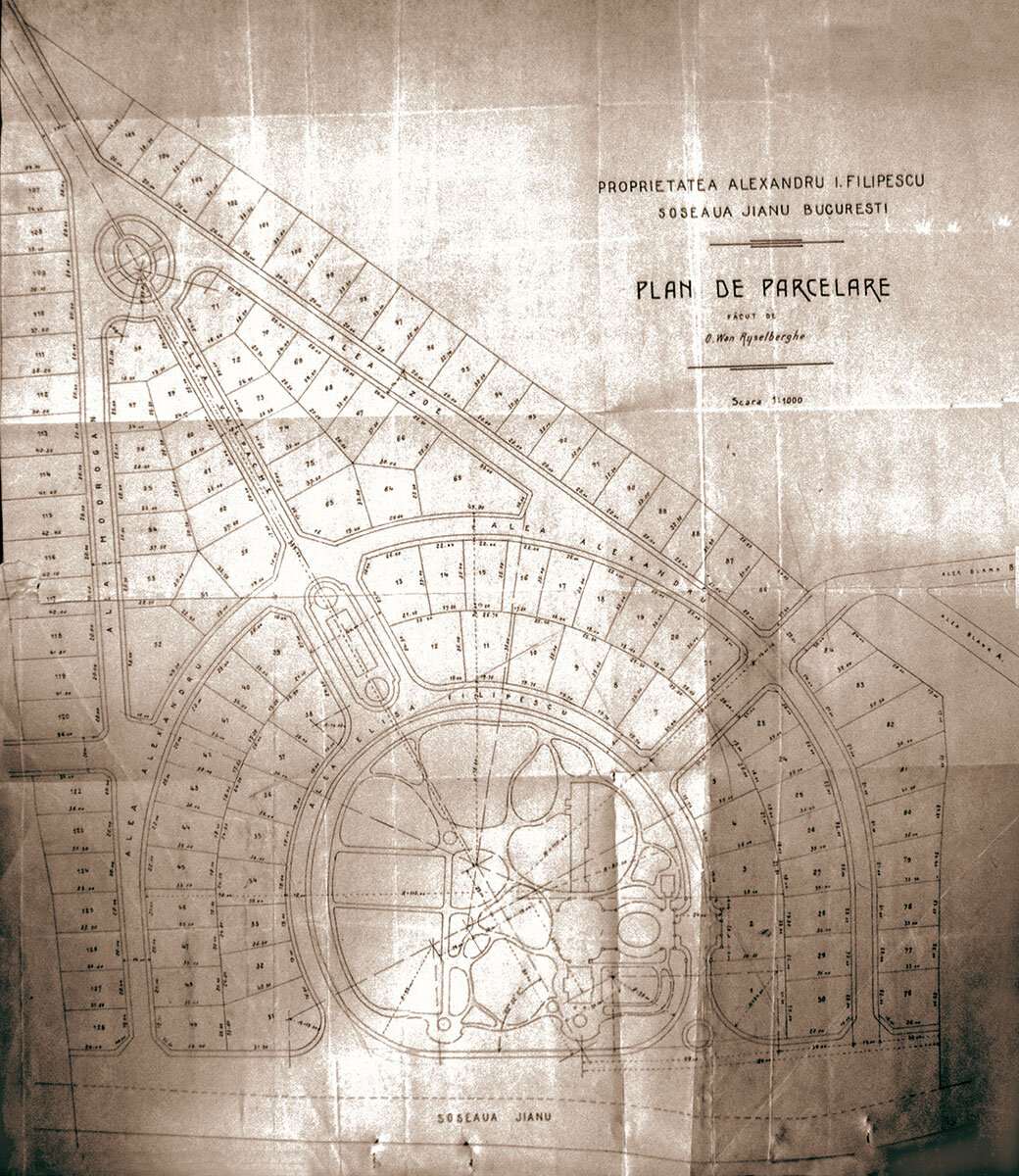
2. Filipescu Parcel
The land known as the Filipescu parcel has a special history. Throughout the 19th century, the Filipescu family made their summer residence here, and in the first decade of the following century, the last heir decided to transform the estate into a neighborhood of villas similar to the models found in European cities. The master plan submitted to the City Hall, one of the most interesting in Bucharest, is based on an elegant composition with generous plots, which allowed for special architectural solutions. This was underpinned by strict rules, potential financial beneficiaries and first-rate architects.
Read the full text in issue 4/2012 of Arhitectura magazine.
Notes:
1. Maria Stan, "Târgul de Afară" de la capul Podului Mogoșoaiei, in "B.M.I.M.", VII, Muzeul de Istorie a Municipiului București, București, 1969, p. 253-259.
2. Until the middle of the 19th century are known: Preda Săulescu (Galben), Mocanu, Ivanciu Gherasim, Niculcea, Ioniță Șerbănescu or Martin Haboș.
3. The fair was held every Thursday and supplemented the exchange activities of the Târgului din Afară where trade was possible on Tuesdays and Fridays.
4. Emil Vârtosu, Ion Vârtosu, Horia Oprescu, Începuturi edilitare 1830-1832, Documente pentru istoria Bucureștilor, I, Bucharest, 1936, p. 42.
5. George Potra, Din Bucureștii de ieri, I, Bucharest, Editura Științifică și Enciclopedică, p. 329-334, Constantin Razachievici, Pavel Kiselev - Istoria șoselei și grădinii cu același nume și a amplasării Institutului de istorie "N. Iorga", in "Anuar al arhivelor Municipielor București", II, Bucharest, 1998, p. 49-94.
6. A.N.I.C., fond M.L.P., file 86/1853, f. 2 verso.
7. Ibidem, f. 3 recto.
8. Ibid.
9. Ibidem, f. 4, 5, 8, 21. The description of the places used by Ioan Alexandru Filipescu, as it emerges from the documents kept in the archives, cannot identify their precise position, so the study of the two graphic representations made by R. A. Borroczyn, in 1846 and 1852, provides additional clarification. The 1852 plan mentions the name Filipescu in two cases. The name "J.A. Philipesko" appears first on a plot of land with a large garden characterized by a circle and alleys, and the second time - on a plot of land neighboring to the south to the first, where "J. Phil" is listed as the owner, most probably the same person. The plan drawn up earlier by the same Austrian major notes the name "Modrogan" for the second plot. This information, together with those in the archive, leads to the hypothesis that this land belonged to the Monastery "St. Sava", and that "Modrogan" and Ioan Filipescu were only the embaticari.
10. Ibidem, f. 8.
11. Ibidem, f. 21, 22.
12. D. Pappasoglu, Bucuresci capitala României dedicat majestatei séle imperator tuturor Russielor Alexandru Nicolaevitz, 1871 and Plan of the Commission of the Yellow Colored Commission of the Capital of Bucuresci dedicated to L: S: Princ: D: B: Stirbeiu, 1875.
13 One of the streets that over the years changed its name many times: Șoseaua Nouă, Jianu (the name change occurred in 1895, probably with the adoption of the law on the city's administrative perimeter boundaries), Aviatorilor, Gheorghe Buzdugan, Jianu, Adolf Hitler, Generalissimul Stalin and Aviatorilor again.
14. Cartul 5 of the Borroczyn plan (1844-1846) mentions the property of Ioan Jianu.
15. Emanoil Hagi-Mosco, Bucharest. Amintirile unui oraș. Old walls. Ființe dispărute, București, Editura Fundației Culturale Române, 1995, p. 117 and Constantin Razachievici, op. cit., p. 86, 87, the latter also presenting a photograph of the fountain and the cross.
16. Henri Stahl, Bucureștii ce se duc, Bucharest, Domino (1910), 2002, p. 44.
17. A.N.D.M.B., P.M.B. Alignments, Plan 514. Plan de aliniere și de nivelment del Șoselei Jianu approved by the Municipal Council in the meeting of March 11, 1902.