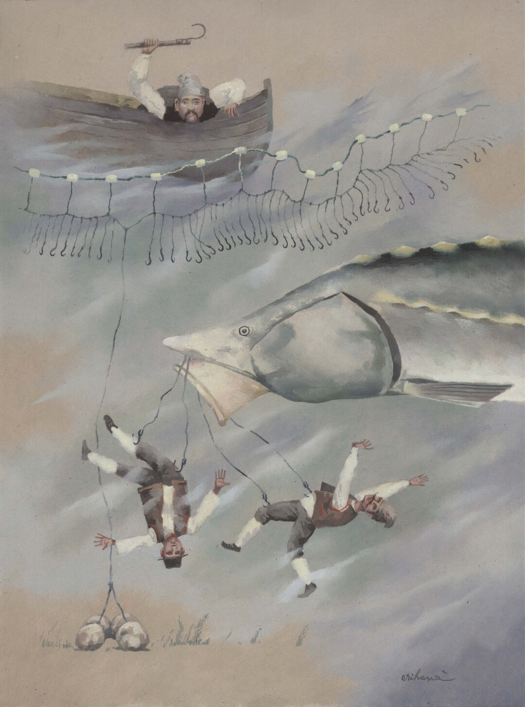
1.075 km
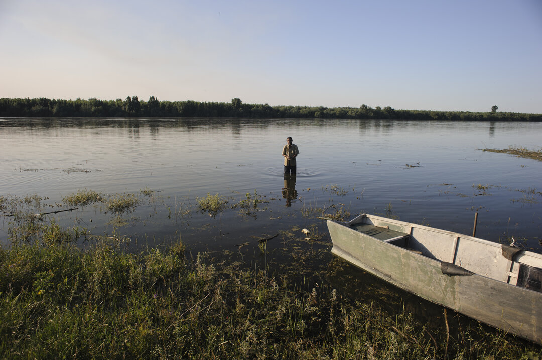
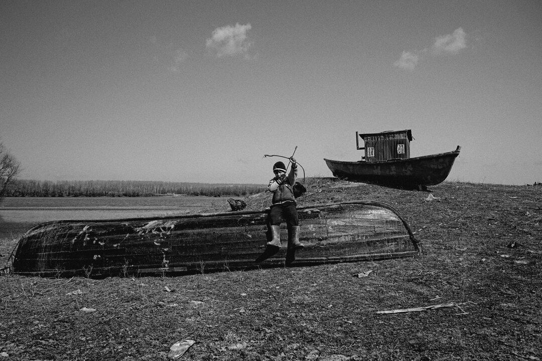
And you go to the Danube
And drink the muddy water...
The evolution of the names of the Lower Danube, from Istru, Phison, Danare, Danare, Donaris, Danubiu, to Danube, goes in step with the history of Romania since Antiquity, marking its important stages. The ancient Greeks called it Istros, Hister or Danaistru. In Theogony, Hesiod's philosophical poem about the genealogy of the gods and the creation of the world, Istros appears as one of the 25 children of the titans Tethys1 and Oceanus2, brother to Nile, Alpheus, Eridan, Struma or Meandru:
"Tethys gave birth to Oceanos the serpentine rivers,
Neilos, Alpheios, Eridanos with their swirling bulbs.
Strymon, Maiandros, and Istros flowing with dome waves,
Phasis and Resos and Nesos, Aheloios, silver wave,
Grenikos, Heptaporos, Rodios, Aliakmonos,
Hermos with phallic wave, sacred Aisepos, Limois,
The charming water, Sangarios, the great river,
Kaikos, Euenos then, divine Scamandros and Ladon,
Parthenius and sacred Ardescos, with the clear waves.
[...]
More rivers flowing with murmuring song in the waves,
Sons of Oceanos, Tethys, the mighty gave them life."3
In his work "Prehistoric Dacia"4 Densusianus (quoting Aeschylus5) calls the Danube "the great and divine river of the ancient world called Oceanos Potamos or Isthus in historical times", "the great river in northern Thrace, called Oceanos Potamos or Isthus in later times"6, "the divine Oceanos Potamos, the father of all waters"7.
For the Romans under Emperor Caesar, the Danube was the God or Father of Rivers, called Danubius and Donaris for the segment from the gorge of the Iron Gates to the sea.
Roman writings referred to the Danube as Danubius, a name that would later be taken over by other European peoples and modified, but with the same sound - Danube for Romanians, Donau for Germans, Duna for Hungarians, Dunaj for Slovaks.
Geographical landmarks
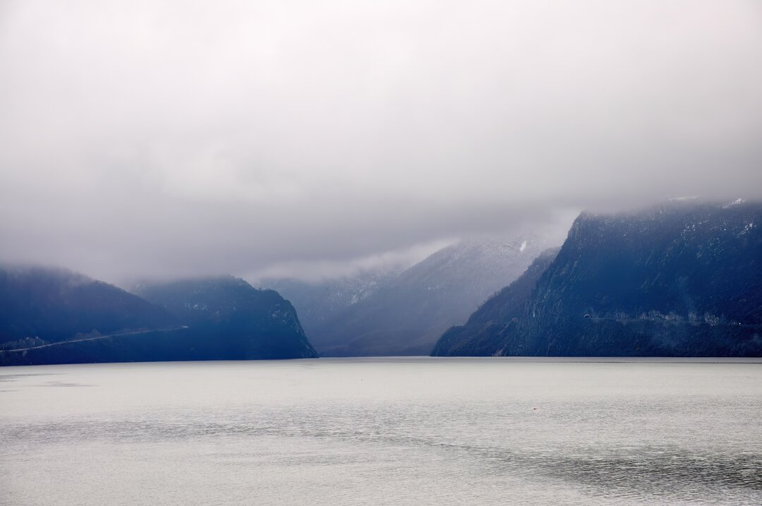
The largest and most important river in Central and South-Eastern Europe, the largest tributary of the Black Sea, the Danube stretches from its source in the Black Forest Mountains to its mouth in the Black Sea, over 2,850 km, draining a basin area of 805,300 km, or 8% of Europe's surface area. More than a third of its length forms Romania's southern border with Serbia, then Bulgaria, from Baziaș to Chilia.
From Călărași onwards, with the change of course to the north, the last part of the Danube's journey to the Sea begins. The waters divide into two main arms, which include between them almost the entire meadow, more than 20 km wide in some places, pools, marshes, lakes, forests, now dammed, drained and turned into agricultural areas (the large island of Brăilei and the Balta Ialomiței). From south of Călărași to Hârșova, sandwiched between the Old Danube to the west and the Borcea Arm to the east, is the Ialomița Lagoon. Near Hârșova, the waters gather in a single bed. Here, the Danube is crossed by Anghel Saligny's spectacular Anghel Saligny railway bridge, at the time the longest railway bridge in Europe and one of the world's major metal bridges with a large span (4,088 m between the left and right banks of the Danube valley), another new rail and road bridge between Fetești and Cernavodă and the Giurgeni-Vadu Oii road bridge. North of Vadu Oii, downstream of Giurgeni commune, the river splits again into two branches: Dunărea Veche (Brațul Măcin) to the east, and Cremenea to the west, which close the Balta Brăilei, intensively modified by dyking and draining).
From Brăila to the Black Sea, the Danube's sea-river sector, the Dunărea Maritimă, which can also be used by large ships, runs along the canalized and rectified Sulina Arm. Between Brăila and Pătlăgeanca, the Danube increases its flow through the large tributaries (Siret and Prut) and flows through a single branch up to the first fork, known as the first ceatal (Ceatalul Chiliei or Ceatalul Ismail, where the Danube branches into the Chilia and Tulcea branches), with large bends (Cotul Pisicii), which favor the formation of ice sheets in spring. The depth of the Danube here reaches 24 m, dropping below sea level. Downstream from Tulcea, the Tulcea branch splits again at the second channel (Sfântu Gheorghe channel) forming the Sulina and Sfântu Gheorghe branches, so that the Danube flows into the Black Sea through three main branches: Chilia, Sulina and Sfântu Gheorghe, the "mouths of the Danube" which have helped form the Danube Delta. Of these, only Sulina is navigable for sea-going vessels; it is continuously dredged, particularly at the spill into the sea, where the so-called Sulina silt bar is created.
From an economic perspective, the Danube provides Europe's most important inland waterway from Ulm to the spillway, and the Main-Danube (opened on September 26, 1992) and Danube-Black Sea (opened on May 26, 1984) canals link the North Sea via the Rhine to the Black Sea, a 3,500 km (2,500 miles) navigable route.
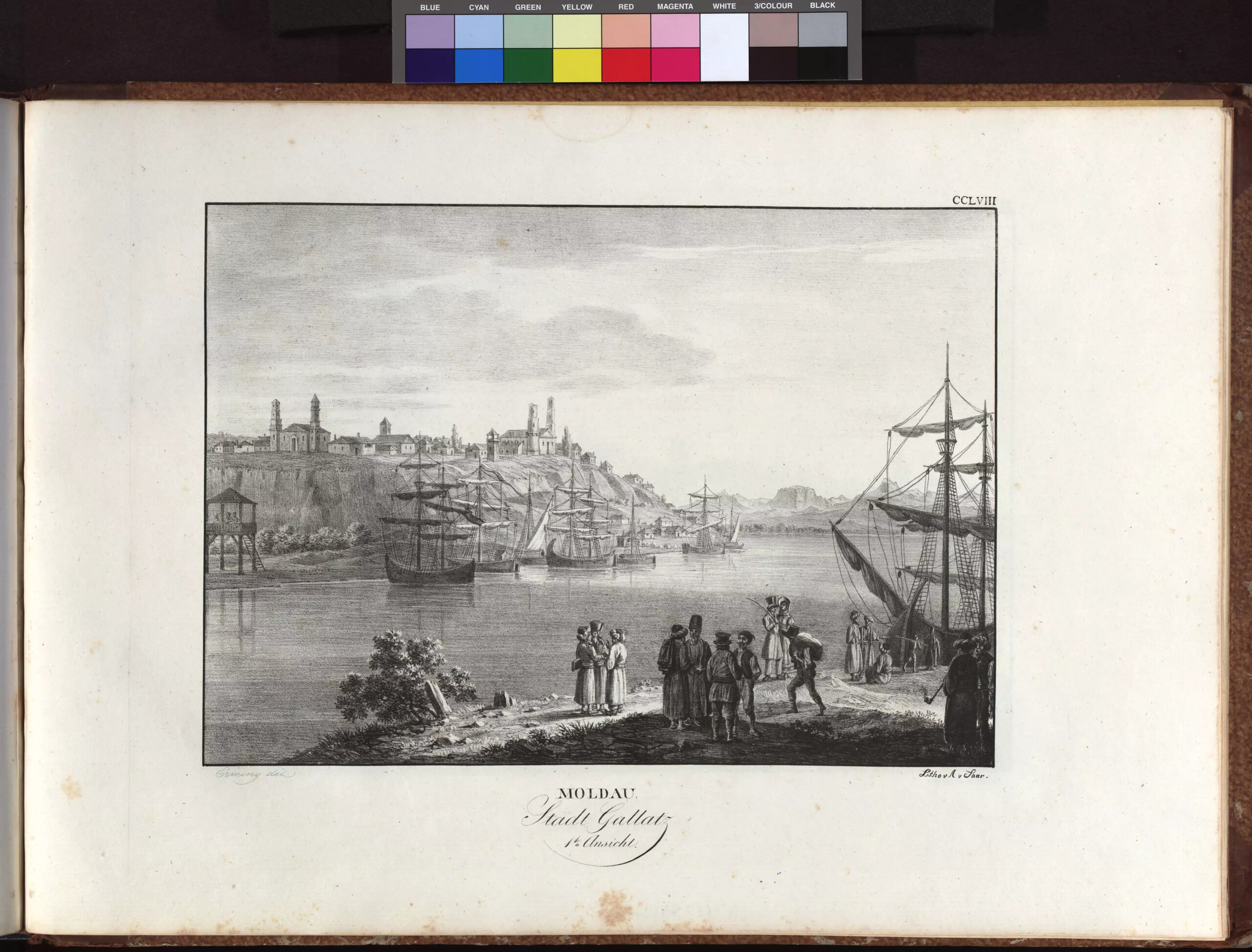
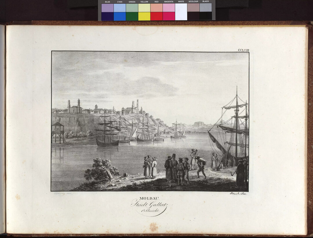
All along the Danube from its entry into Romania, at the mouths of its tributaries Jiu, Olt, Călmățui, Argeș, Mostiștea, Ialomița, Siret, Prut, as well as at the bridges that cross it, the Danube has, at different historical stages, favored the creation of ports and fairs, fortresses and cities.
At the same time, the configuration of the Danube Delta at its spill into the Black Sea and the old Danube inlets, which were favorable to navigation sheltered from the winds, currents and storms of an almost closed maritime basin, favored anchoring, mooring, the creation of ports and related urban structures.
From the Danube to the Sea. Dobrogea, a landscape unit
[...] this land of Dobrogea, covered with the ruins of successive civilizations, [...] this land between the sea and the Danube, half granite and half clay, [...] this land where the scree grows tall and straight above the grasses like temple candlesticks [...] has something of the grandeur of the steppe. [...]
[...] On the roads of Dobrogea, winding among the mysterious megas, strange lakes interrupt the gray, sad and majestic monotony of the tired land. And the meandering roads lead you to the Danube in a constant sense of unreality, as if the soul were oscillating between dream and death.8
The Dobrogea is an atypical space, difficult to judge in patterns. In an attempt to understand as accurately as possible what are those characteristics that qualify it as atypical, the space between the Danube and the Sea must be seen in a zonal context and evaluated in an informed way.
We cannot talk about the settlements of the maritime Danube without understanding the processes of structuring the territory of the Dobrogea, as they appear to us today. For a proper understanding of their evolution, it is essential to identify and characterize the major historical stages that shaped them. In this respect, a particularly interesting study in the early 2000s on the "Protection and promotion of port cities and territorial systems related to the Romanian course of the Danube", carried out by a team from the UrbanProiect Institute9 , proposed to approach the territory defined by the Danube and the Black Sea as a "landscape unit"10, as a whole structured by the presence of the Danube, an integrating element that has induced relationships that have maintained their strength throughout history - an approach that represented a concrete step in the field of protecting this territory.
The study documents11, argues and emphasizes the coherence of the evolution of the Romanian territory of the Danube and the strong relations that link it to Dobrogea, despite long periods of administrative delimitation.
The fact that this great river empties into the Black Sea - about a third of the 'Romanian segment' of which runs through the territory of Dobrogea - and the reality, which is not negligible, of the unique shape of the final course of the river, the Danube Delta, create a double system of determinations: the orientation of the Danube territory towards the sea and the fact that Dobrogea is the country's interface with the Black Sea.
The Danube - Black Sea territorial system
The two territories - the Dobrogean and the Danube - have evolved in remarkably different ways, sometimes even with real phase shifts. In this respect, it is worth mentioning, on the one hand, the long, inauspicious period during which the Danube remained only a border, a dividing line, and, on the other hand, the periods of Ancient Greece, the Roman Empire and the Byzantine Empire, which were prosperous periods for the flourishing of Black Sea navigation, when colonies were established on the coast (and inland) and trade developed.
The Ottoman Empire brought major changes in maritime trade, blocking Europe's traditional links with the Far East, and trade in the area lost its international character, with direct effects on maritime trade and port cities in the Mediterranean and Black Sea.
In all these stages, the Danube maintained its role as a linking and articulating element between the two sub-units of the Danube-Black Sea territorial system, a role that was, of course, reinforced after the re-partition of Dobrogea to Romanian territories.
The Danube and the Black Sea are analyzed in this study as systems constituting a coherent whole, especially from the 19th century onwards, with the integration of the Danube as an important element of the continental trade network.
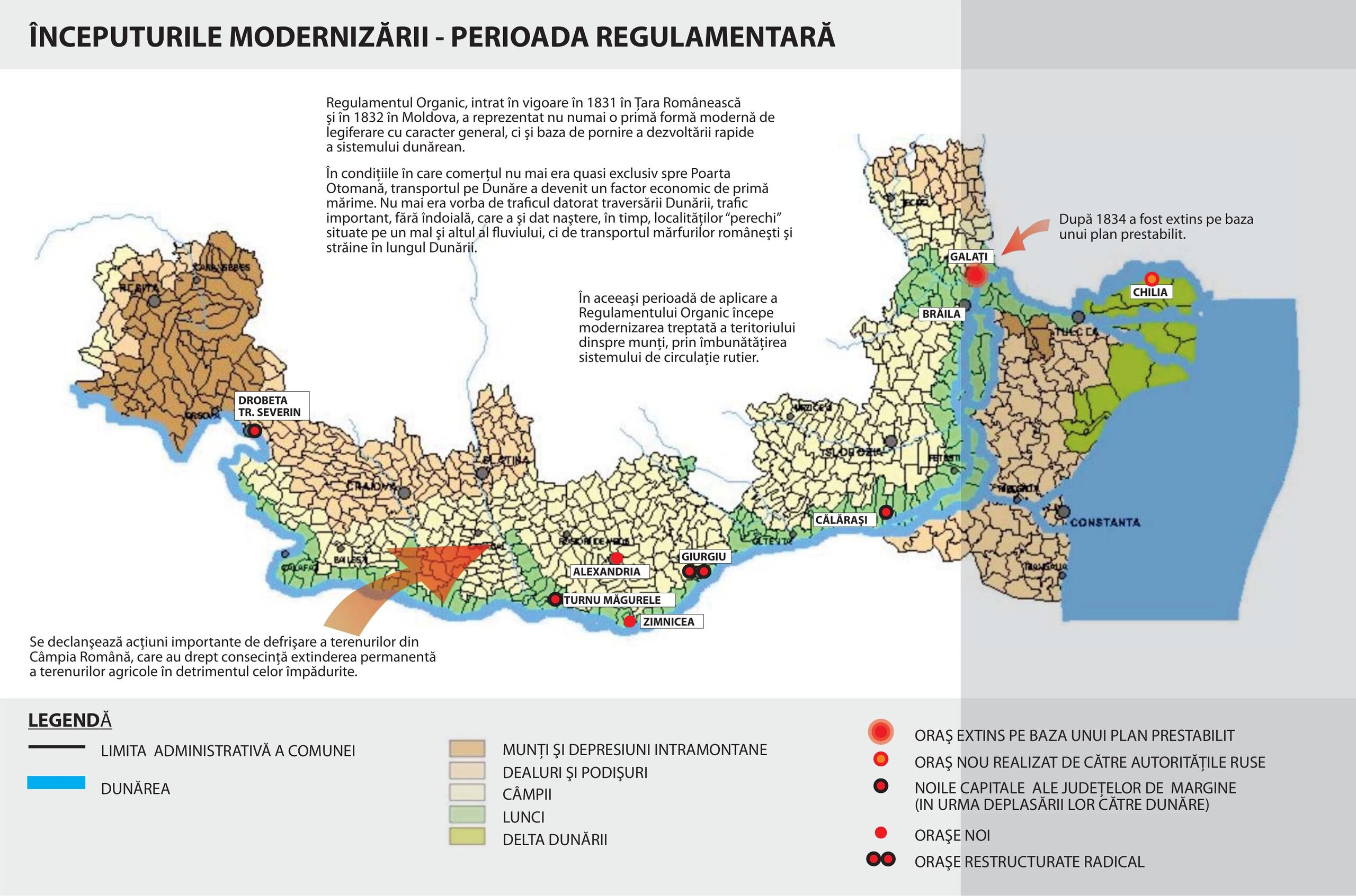
The process of modernization of Dobrogea since the first part of the 19th century12 - when the Danube was the border of the Romanian Principalities with the Ottoman and Russian Empires, from Vârciorova to the sea - was closely linked, directly or indirectly, to the Danube transport, a determining factor in the development of the territory crossed by the river.
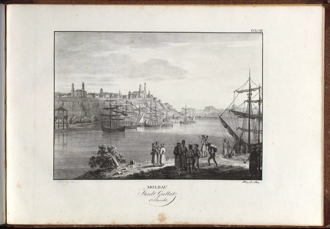
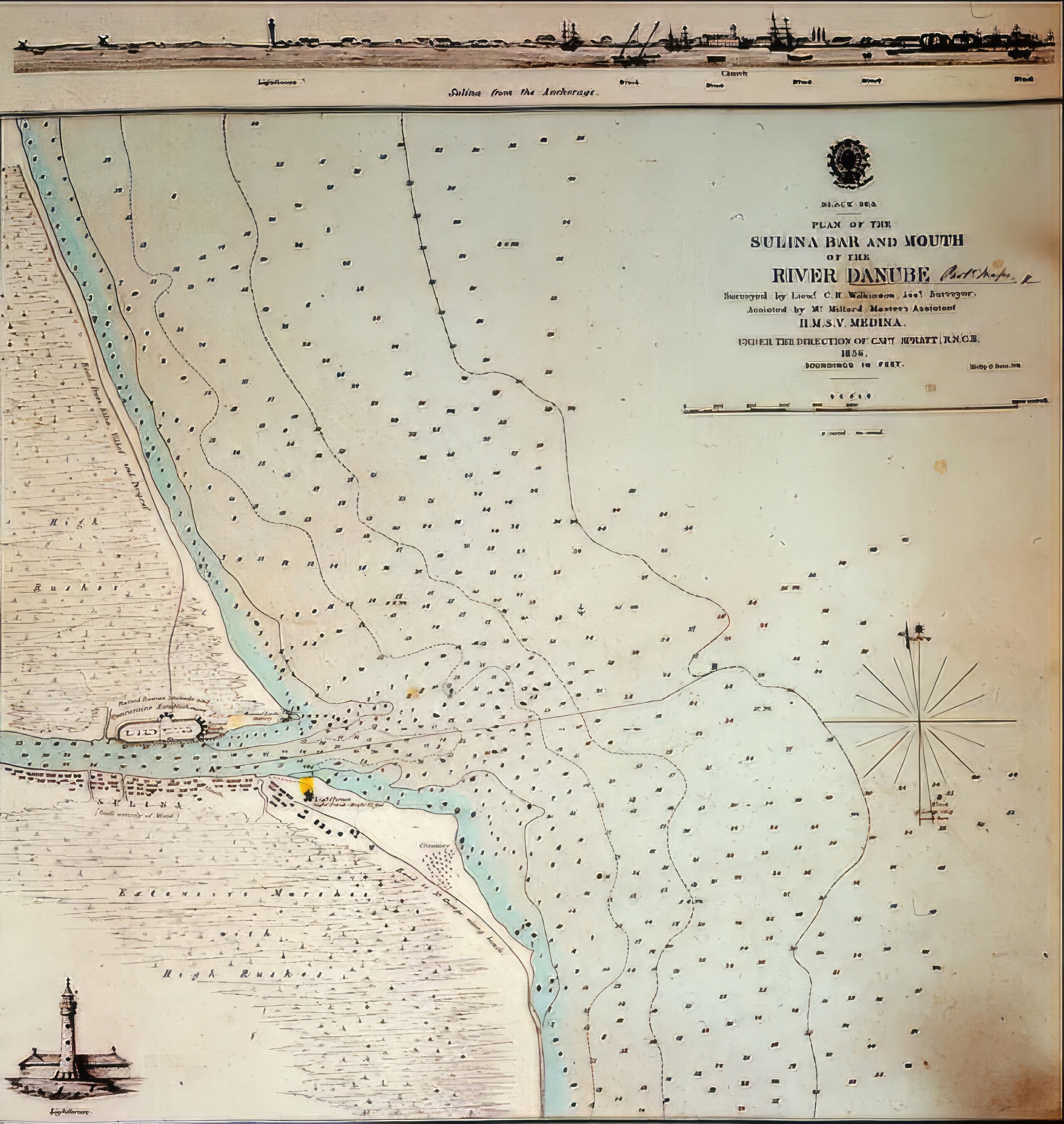
Numerous events mark the development of the processes that shaped the territory between the Danube and the sea: international agreements - the Treaty of Bucharest in 1812, the Treaty of Ackermann in 1826 and then the Treaty of Adrianople in 1829 (which facilitated transport from central Europe to the Black Sea and further to the East, gradually ensuring the free movement of goods and passengers in favour of Russia and Turkey and, after the disappearance of the Turkish monopoly, the liberalization of trade in the Romanian Principalities) the establishment of the European Commission of the Danube in 1856, which established not only the legal framework for the use of the Danube for transportation, but also the means of maintaining the navigable channel (by regular dredging) and improving navigation conditions. In this respect, the improvements made at the Danube's mouth at Sulina and the creation of the quasi-rectilinear Sulina navigable channel, by abandoning its previous meanders (after 1857), are important, not least for their implications for the configuration of the territory and landscape.
The pre-war period was decisive in shaping the modern Danube - Black Sea territorial system. The political context favored this process. The Union of the Principalities and then the proclamation of independence and the Congress of Berlin in 1878, following which Dobrogea was annexed to Romania, were the most important moments that spurred the general development of the country and, in particular, of the territory of Dobrogea.
Within this new political framework, Dobrogea began to integrate organically into the new Kingdom of Romania, an integration that was enshrined in the Law for the Organization of Dobrogea of 1880.
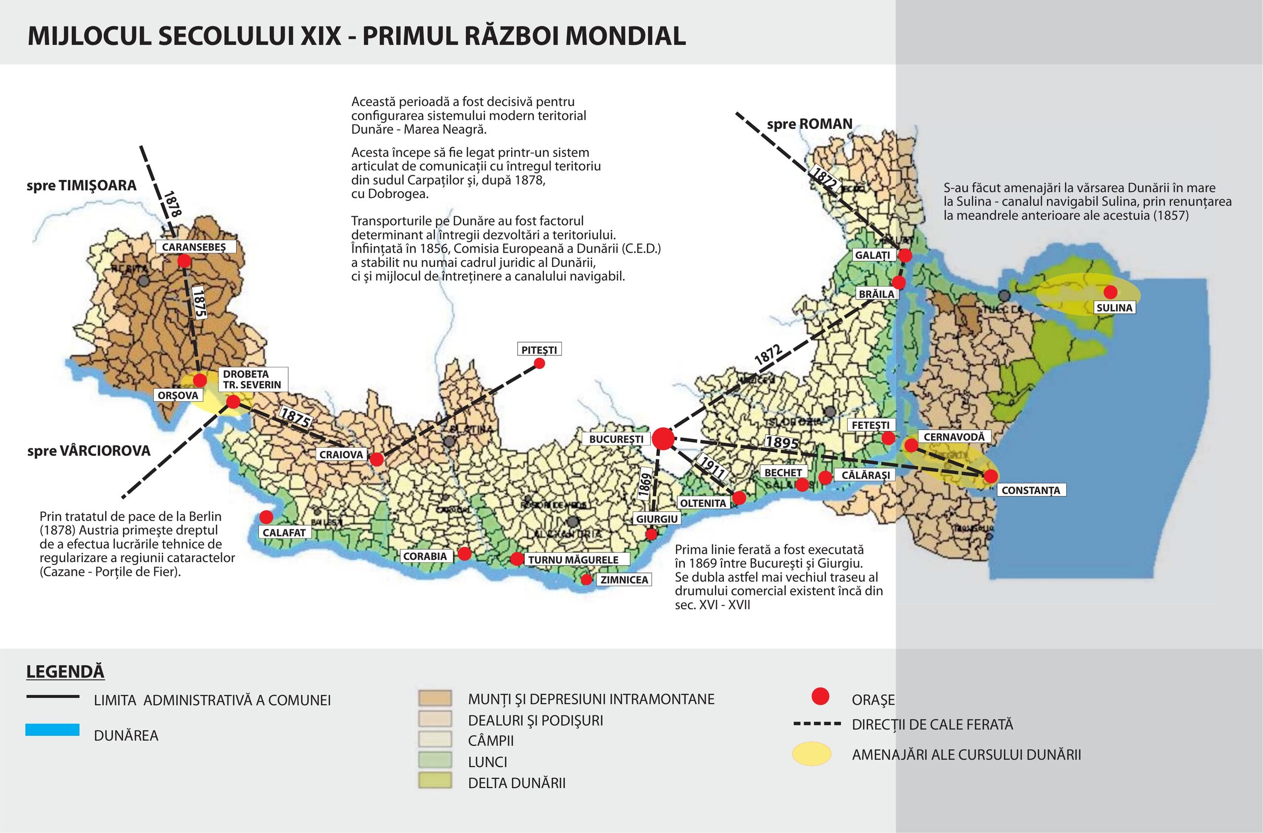
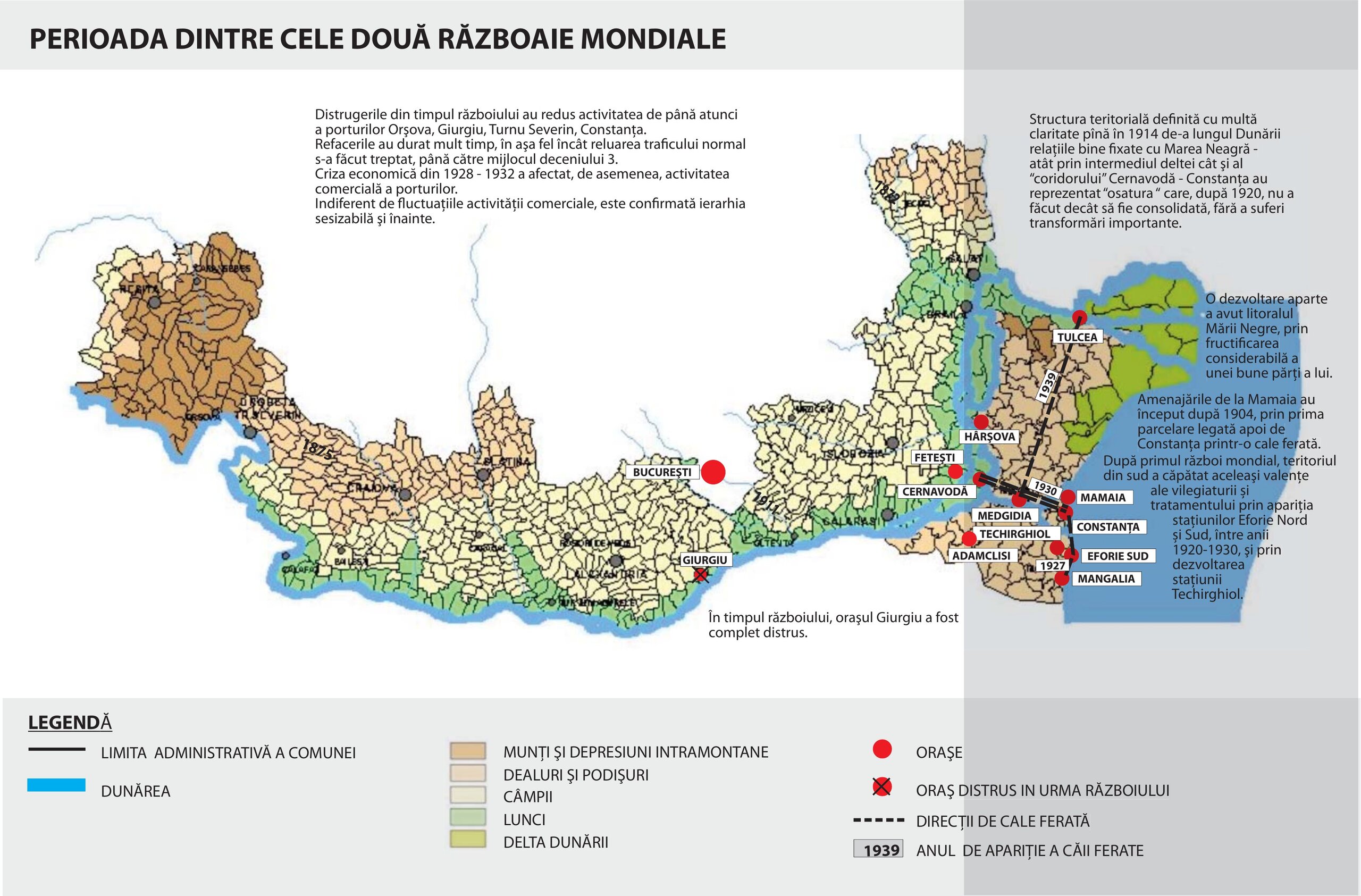
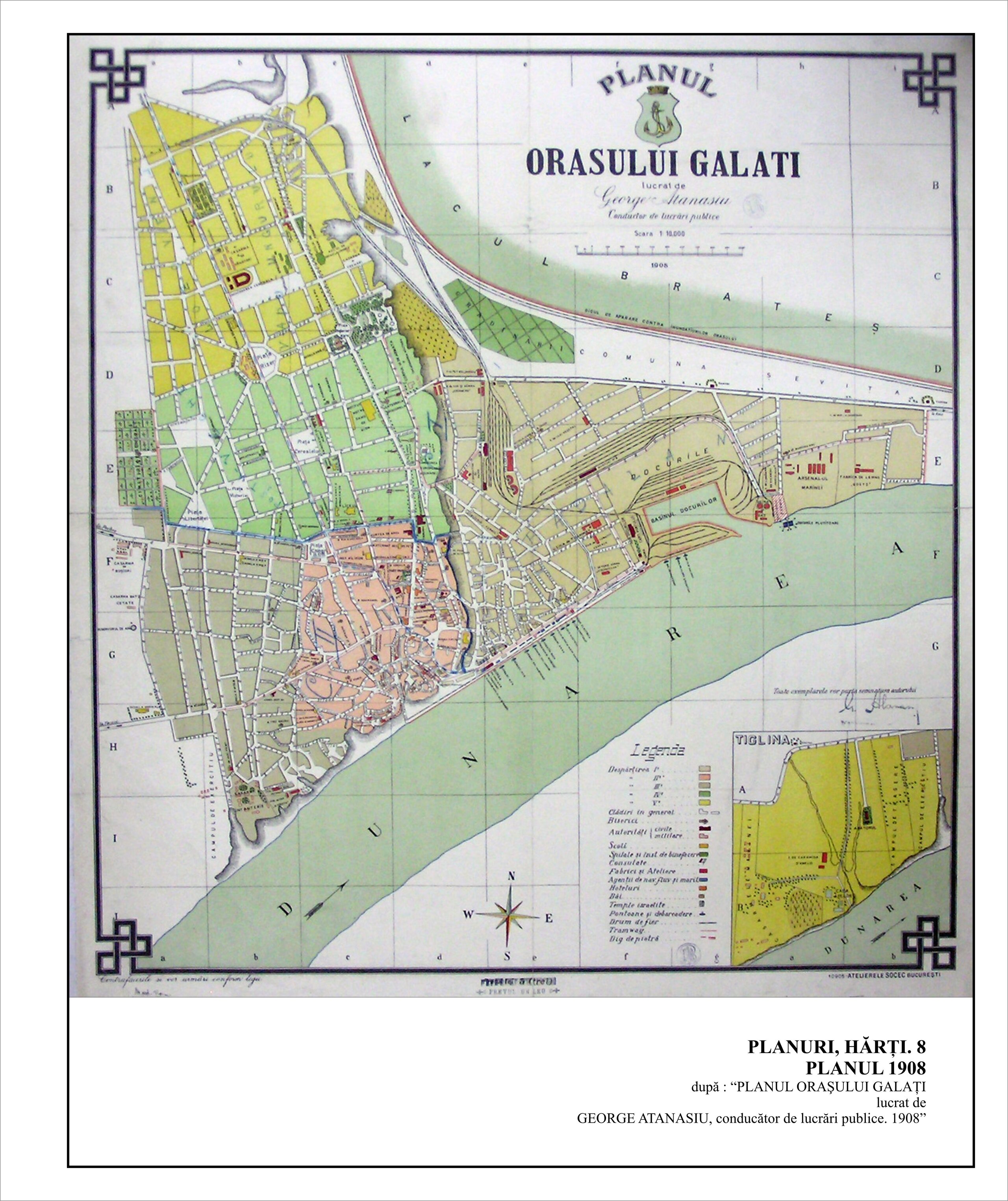
Dobrogea's territorial system began to crystallize the functional characteristics that still define it today, it began to connect with the entire territory through an articulated system of communications, especially through the railway network in full construction boom (unprecedented and unparalleled to this day) with Bucharest as its main hub and extending into Transylvania, Banat and Bucovina, territories belonging to the Austro-Hungarian Empire. The main Danube ports were very quickly integrated into the national railway network between 1872 (Brăila and Galați) and 1875 (Vârciorova). The railway line from Constanța to Cernavodă, built by the English company John Trevor Barkley and inaugurated in 1860, was rebuilt and linked to Bucharest in 1895, with the construction of the section between Bucharest and Cernavodă and the opening of the bridge over the Danube. The territory of the Dobrogea was equipped with the essential routes establishing multiple river and land links between the areas under the influence of the Danube and the Black Sea: in 1915 the section between Medgidia and Hamangia was completed, and by 1939 the line to Tulcea was fully completed, on a route that crosses the entire territory of the Dobrogea. In 1927, the railroad between Constanța and Eforie Sud was completed, and in 1938 its continuation to Mangalia. Finally, in 1930, the Constanta - Cernavodă railway was doubled.
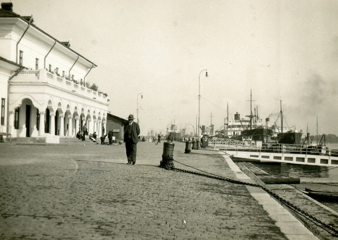
In this context, the larger cities (Constanța, Tulcea, Sulina, Cernavodă) developed rapidly, their main function being that of a port, which required specific facilities depending on the importance of the port in question: for secondary ports, minimal facilities, so-called scaffolding; for main ports, extensive, complex facilities, spread over large areas of land, differentiated passenger and dock ports, berths, warehouses, warehouses, river stations, railway yards, etc. The layout of the cities closely followed the development of port activity, with the presence of all the characteristic architectural programs typical of the end of the 19th century (administration, various commercial and cultural facilities, hospitals, educational institutions, etc.).
After 1920, the territorial structure defined until 1914 along the Danube, the links with the Black Sea on the one hand and with the rest of the national territory on the other, were consolidated without undergoing major changes.
Port cities on the Danube,
nodes of landscape unity
In the evolution of the system of Danube port cities, from small settlements in fords, often with a strategic role and therefore fortified, to port cities built for the first time in the history of the Romanian Lands, on the basis of plans drawn up in advance during the regulatory period, there is an exceptional coherence, which is noticeable even in the current crisis. Under the combined effect of the re-establishment of movement on the Danube, in the context of the continued growth of interest of the great powers of Western Europe in the eastern part of the continent (and, implicitly, of their presence in this area) and the establishment of large agricultural exploitations producing and exporting grain, the port cities gained increasing importance in the way the territory of the Principality and the reunited country were organized - an importance that is maintained, with fluctuations, until the crisis situation in which we find them today, a situation that reverberates, of course, over the entire territory.
The historical evolution of the port-cities in the area of reference, their 'rise and fall', shows several paradigms: continuities from antiquity to the present day (Aegyssus/ Tulcea, Noviodunum/Isaccea, Carsium/ Hârșova, Durostorum/ Silistra), medieval foundations that last to the present day (Brăila, Galați, Ismail, Chilia), ephemeral creations or lasting a few centuries (Sun's Pasture/Vicina, Babadag, Karaharman), some of which have not yet been identified (Lycostomo)"13. It should be noted, however, that the idea of continuity needs to be relativized, as the settlements in question developed with different emphases after each period, and there were sometimes syncopations, with activity resuming at different rates over a somewhat wider area.
European Danube Commission,
a unique historic opportunity for the region's development
Its status as an international river and the strategic position of its mouths have aroused major interest among the major European powers in controlling navigation on the Danube up to its mouth in the Black Sea. Given that Romania has the largest and most navigable stretch of the river, including for seagoing vessels (the sector between the Black Sea and the ports of Tulcea, Galati and Braila), Romania has been at the center of these concerns, becoming a more or less active partner in the discussions, depending on the historical context.
The eventful history of this disputed strategic area of the country has seen many ups and downs, wars, treaties, peace agreements, conventions and conferences, a tangled web of historical, economic and political interests and disputes, fascinating and revolting at the same time, which we cannot go into in detail here. What is certain, however, is that the role of the great European powers in this process, which was of course driven by economic and political interests in the Danube mouth area, was very important in the development of the area between the Danube and the Sea, forcing their development, marking the evolution of the port cities and, implicitly, of the entire territory around them, a reality which is still perceptible today.
The expression of this huge modernization effort is, of course, the European Danube Commission, an international body which, for almost nine decades (1856-1948), managed navigation on the Danube maritime sector. The Commission functioned as an authority independent from the laws of the Romanian state, with its own administrative, legislative and legal system.
The E.E.D.C. was considered by the Western powers (not by Russia, which did not like the presence of an international body in its area of influence and did everything in its power to sabotage it) as "one of the most successful and suggestive experiments in international administration", an exercise in the administration of an international institution controlled by the major European powers with important economic interests at the mouth of the Danube, in which the riparian countries played a symbolic role.
The Treaty of Peace of Paris of March 30, 185614 is the founding act of the European Commission for the Danube, referred to in the Treaty as the European Commission. It is the first act to set up an international commission to regulate the free movement of vessels on the Danube, initially as far as Tulcea and then as far as Isaccea, Galati and finally to Braila. While the previous international treaties and conventions that had regulated the movement of vessels on the Danube were the result of bilateral agreements between different states or regulated navigation on certain sections of the Danube, the Treaty of Paris is the first act to provide a set of uniform rules for the entire course of the river.
The provisions of the Treaty of Paris were based on the principles of free navigation on international rivers laid down in the Final Act of the Congress of Vienna in 1815 and recognized that these principles should also apply to the Danube and its mouths into the Black Sea.
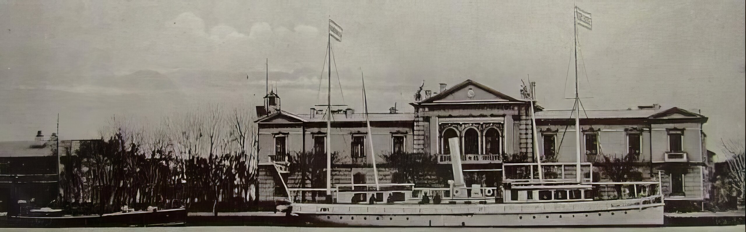
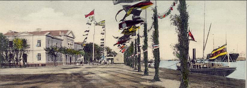
But nothing good lasts for long - although 90 years is not a short time - in a hostile environment. Russia again, this time in the form of the Soviet Union15. The European Danube Commission was abolished at the International Conference in Belgrade, July 30-August 18, 1948, attended by representatives of Austria (in an advisory capacity), Bulgaria, Czechoslovakia, France, Great Britain, the USA, Ukraine, Hungary, the USSR, and the USA, when a new Commission was set up with representatives of the riparian states - Romania, Austria (became a member in 1960), Germany (the former FRG had an observer role until 1990). The headquarters of the Commission was initially established in Galati and later moved to Budapest16, with the task of managing the traffic on the navigable section of the Danube between Ulm and the Black Sea (navigable section of the Danube), through the Sulina Arm.
In Belgrade, in 194817, the Soviet Union tried to legalize its monopoly over the Danube - "Danube for Dan Dananians" (a sort of "we won't sell our Danube!") was the Soviet slogan presented in the draft Convention, drafted by the USSR - using its influence over the six riparian countries. The adopted and voted act fully reflects the Soviet proposal on the content of the treaty.
The Belgrade conference is considered a failure on the Danube, which remains divided and inactive on the question of river traffic. Ambassador Cavendish Wells Cannon, head of the American delegation to the 1948 Conference, said at the time: "The Soviet attitude destroys the whole concept of international waters which has been public law in Europe for 130 years".
The major merit of the C.E.D. was to form a structure for regulating the movement of vessels on the Danube by creating river police regulations, navigation regulations, a legislative framework and a legal system for settling disputes relating to river trade. The realization of the legislative framework for navigation on the Danube has made it possible to fluidize navigation in the maritime Danube sector and has contributed to the smooth navigation of the entire navigable sector of the Danube.
The creation of navigable waterways on the Lower Danube and connecting the Black Sea with the river sector was made possible by the interventions of the EDC on multiple levels: large-scale hydro-technical works for the canalization of the lower Danube, an administrative infrastructure located in key points of the Danube course (navigation inspection headquarters, administrative headquarters, pilot agencies, customs and river police agencies, etc.), regular dredging and maintenance works on the waterway.
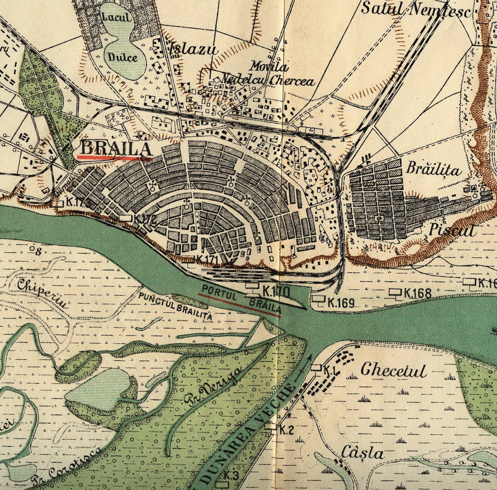
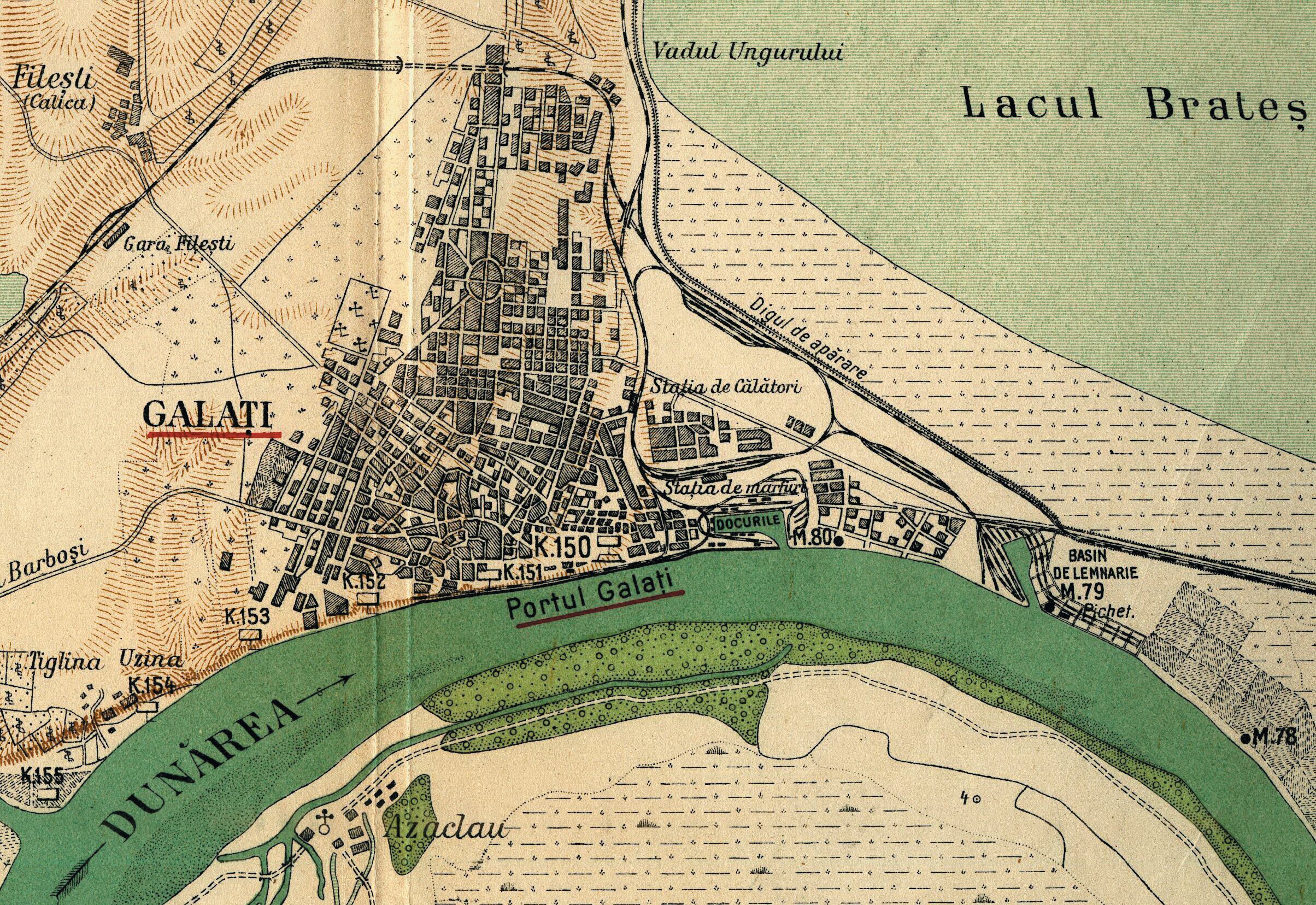
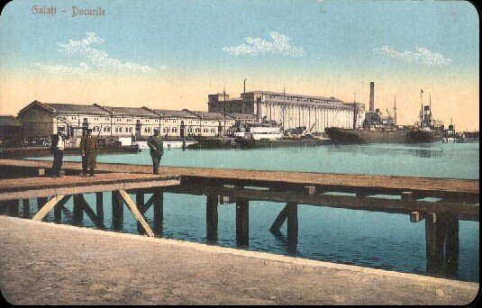
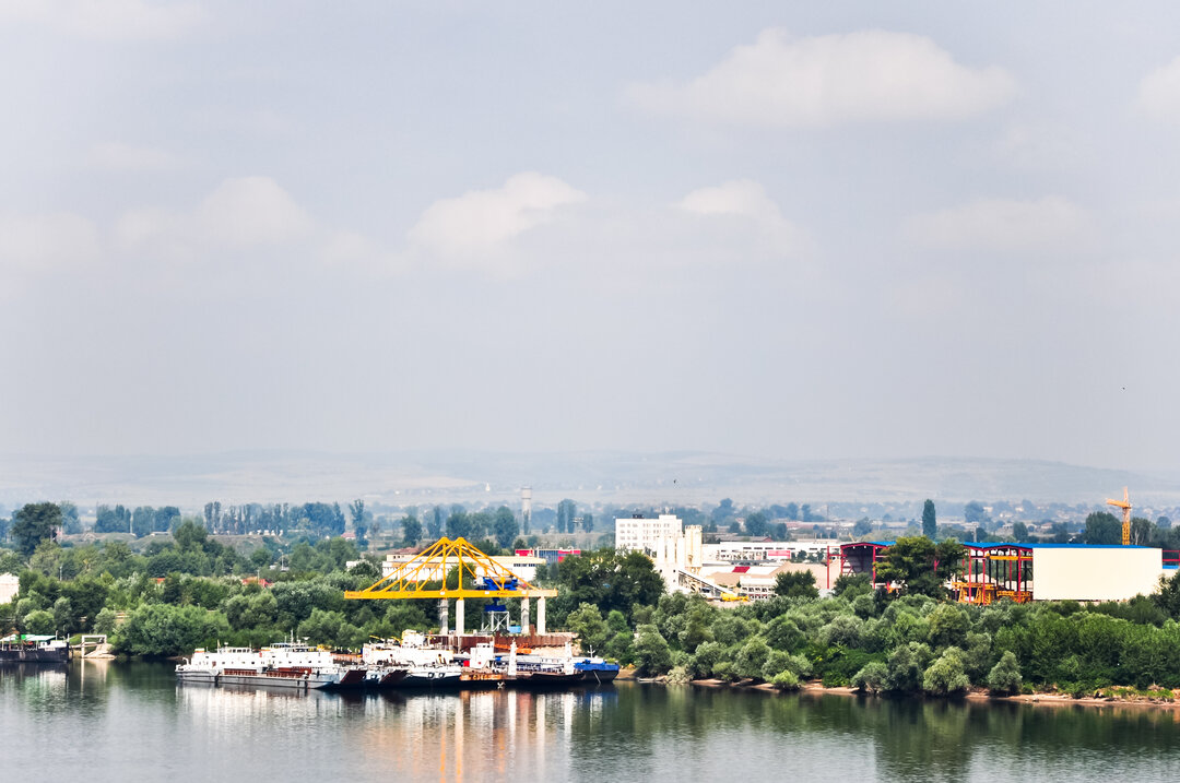
At the urban level, the impact of C.E.D. at the level of the cities analyzed is different. The dredging and systematization of the Danube carried out by the C.E.D. led to the transformation of the ports of Brăila and Galați into sea-river ports, and the state investments in the development of the port infrastructure allowed the development of these cities in the second half of the 19th century.
The port built heritage built during the period of activity of the C.E.D., when river trade was the engine of development of the cities and governed the territory adjacent to the Danube - buildings and technical constructions realized by the C.E.D., the Romanian state and foreign shipping agencies - is particularly valuable from the architectural, urban, historical and cultural points of view.
The buildings constructed then, with an imposing volumetry and an architectural language that reflects the current architectural styles of the end of the 19th century and the beginning of the 20th century, form coherent ensembles that integrate technical equipment specific to ports (wharves, wharves, elevators, cranes), signaling and coordinating the movement of ships (lighthouses, river stations, beacons, life-saving systems), outlining the urban silhouette and the urban waterfront of the port cities.
The development of the cities under the influence of port systematization works resulted in an increase in port traffic, an increase in the quantities of exported goods and, indirectly, in the development of the port's built-up area and technical infrastructure. All these port infrastructure development operations, undertaken by the EDC and the Romanian State, have contributed to the expansion of the interest of European states and foreign companies in the establishment of consulates, transport agency headquarters in Romanian port cities and to the accentuation of the cosmopolitan character of the urban settlements.
The development of the port infrastructure and of the port cities in the modern period was carried out in parallel with the systematization works of the maritime sector of the Danube, elaborated by the European Danube Commission under the protectorate of the great European powers. The cumulative effect of these clear directions of urban and territorial development was the development of river trade and, implicitly, the economic development of the port cities.
European Danube Commission (EDC)
and updating cartographic material
The presence of the European Danube Commission in Sulina led to the imposition of high cartographic standards. The extensive construction effort initiated by the E.E.D.C. in the maritime Danube area was supported by detailed maps that provided important geographic and urban planning information.
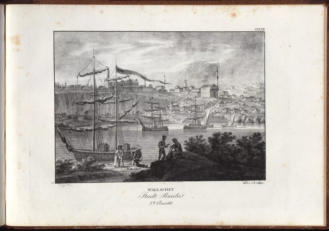
Prior to the establishment of the EDC, the relevant maps for the Lower Danube and the Delta area were the maps produced in the 1770s-1780s and the military maps from around 1830 illustrating the borders between the Ottoman Empire, Russia and the Romanian countries and detailing the area of the Danube mouths (in 1828, Military Sketch of the Area between the Danube and Constantinople, published by James Wyld - King's Geographer, London), highlighting the delta area, the marshy area of the Danube, the fortifications along the Danube and the seaports; The Map of Navigation on the Danube between Sulina and Brăila (1789), produced in Vienna by Lauterer and Mansfeld, shows the profile of the Danube and the Sulina Arm with the settlements adjacent to them.
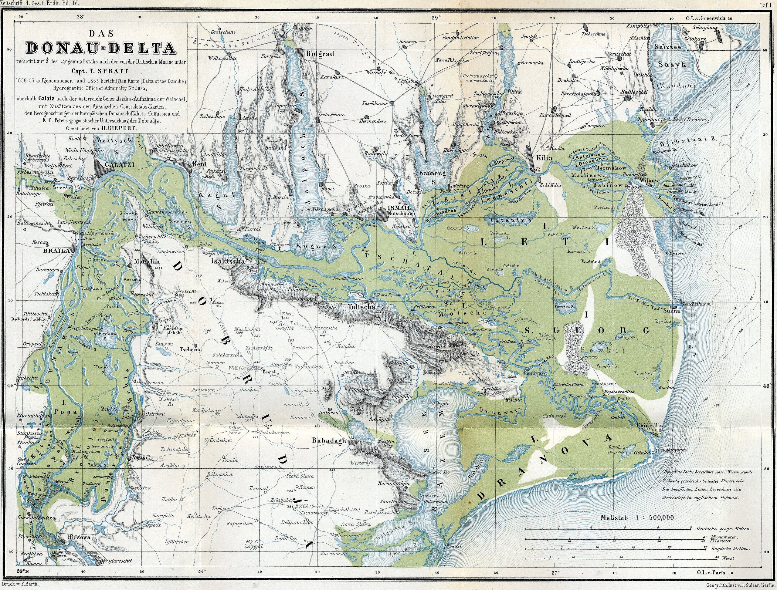
The first accurate map of the Danube Delta, produced in 1865 under the guidance of Captain Spratt, depicts the Danube Delta and the Danube Balti area in great detail, and its quality represents a major leap forward in terms of illustrating the Danube Delta and the navigable area of the Lower Danube.
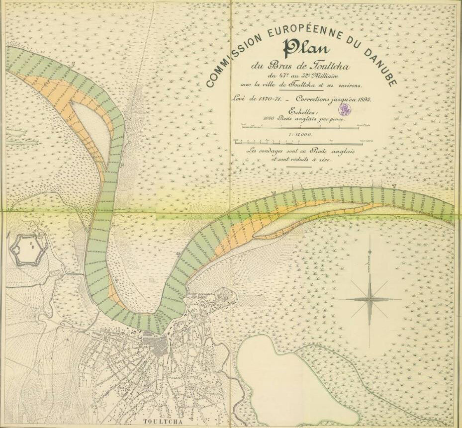
For the knowledge of the evolution of the city-ports between the Danube and the Black Sea, the maps produced during the period of activity of the C.E.D. have provided very valuable periodical information. Map sheets produced for segments of the navigable arm of the Danube that include plans of the adjacent cities at various stages of evolution are a source of information for urban history studies. Their contribution is all the more important as they deal with a territory which, at the time these plans were drawn up, was not under Romanian administration or was newly annexed.
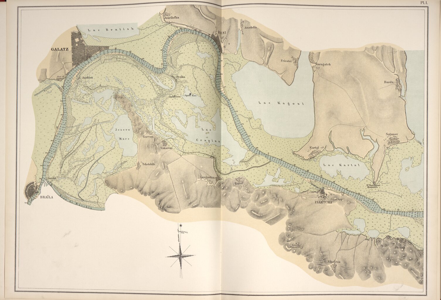
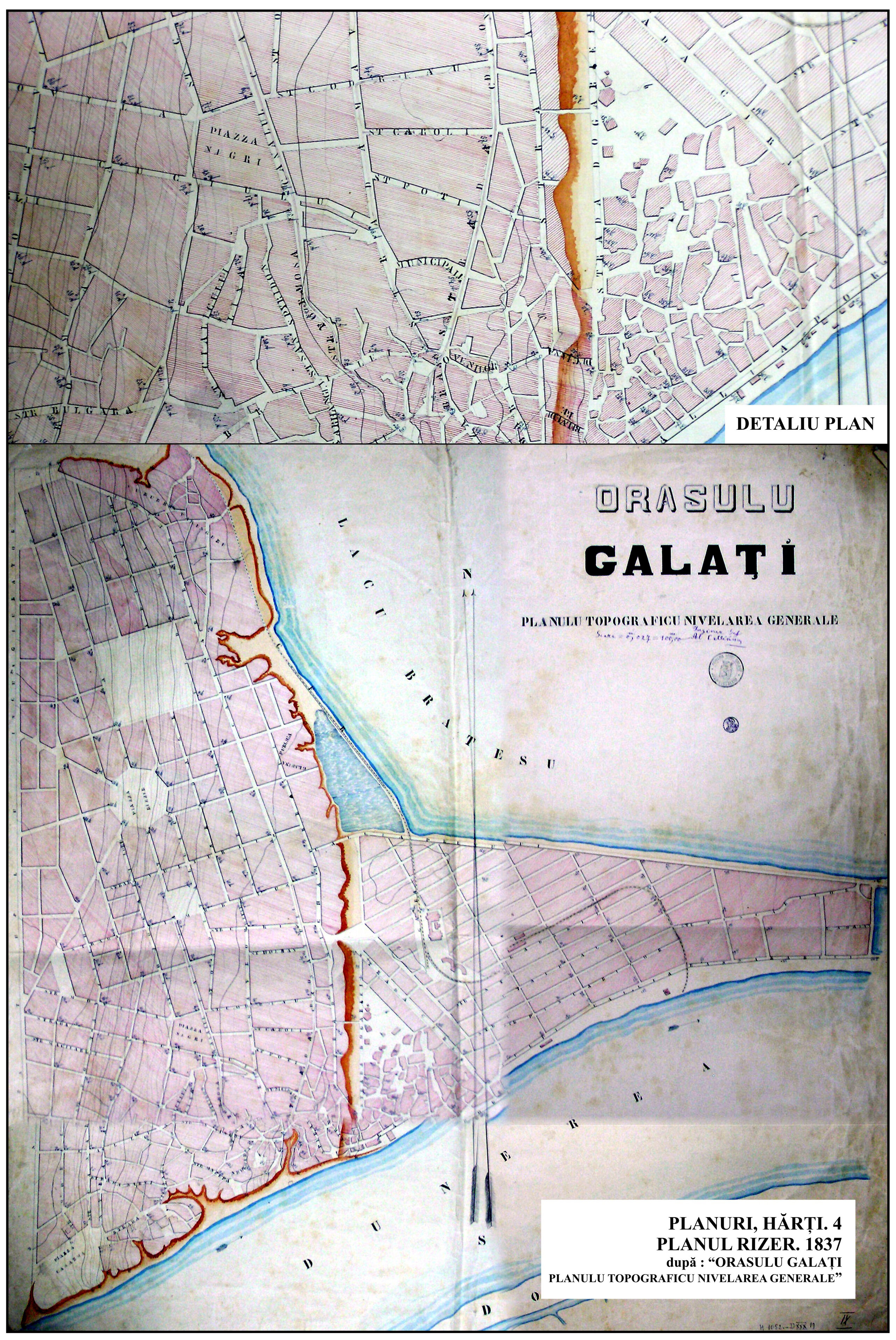
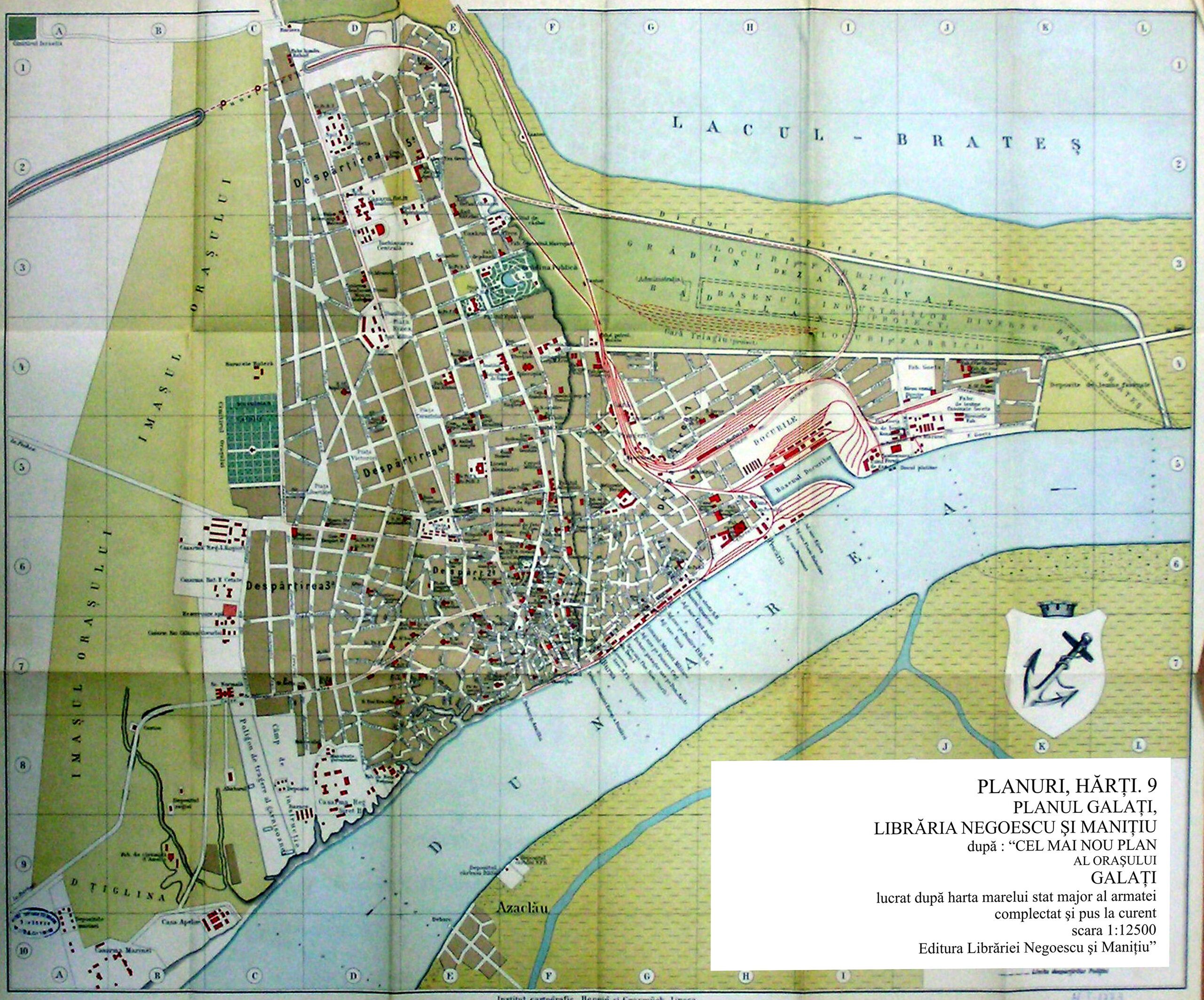
Thus, the periodical maps made for the systematization of the mouth of the Sulina Arm provide important information about the evolution of Sulina and the way it expanded towards the Black Sea coast; the maps of the systematization of the Sulina Arm and the Sulina-Galati waterway provide detailed information on the shape and structure of the towns adjacent to the Danube (Sulina, Tulcea and Sf. Gheorghe); the plans made for the towns of Isaccea and Tulcea between 1870 and 1895 are a valuable source of information. General maps of the course of the Danube inlets provide information on the formation and evolution of human settlements in the Danube Delta area, and their names in the 19th century. General information about the urban form of the main towns located along the Danube: Brăila, Galați, Ismail, Tulcea, Isaccea, Reni, Isaccea, Isaccea.
In this regard, on the Map of the Danube and its mouths, between Brăila and Mare, drawn up in 1870-1871 by Robert Hansford, geodesist, and Charles Kuhl, civil engineer, under the guidance of Sir Charles A. Hartley, called "Father of the Danube", between 1856-1871, chief engineer of the C. E. D., then consultant on river and maritime navigation matters, corrected in 1886 for the above-mentioned towns, the main street layout, urban squares, blocks of buildings, areas adjacent to the waterfront where ports are located or reserved for port development, the positions of lighthouses located along the Black Sea shore, railroad lines, main access roads into the towns and connections with neighboring towns can be identified. The vignettes on these maps illustrate these towns as seen from the Danube at the time of the measurements.
Not ports and cities, but port-cities
It can be said without any exaggeration that the port areas of the cities on the Danube were the creation of the European Danube Commission. Starting in the mid-19th century, in a favourable economic and political context, the development of these cities was accelerated by the Commission's regulations on the conduct of inland navigation, which ensured the smooth functioning of the waterways through regular systematization and maintenance works and, last but not least, through investments in the ports. C.E.D. was involved in the urban, social and economic development of these port-cities, either directly - through port infrastructure construction works that had a direct effect on the economic development of the Danube port-cities and through the expansion of the port and navigation infrastructure - or indirectly, through hydro-technical works to improve the fluidity of river traffic at the mouths of the Danube and through the creation of a regulatory and legal framework for the development of trade and river traffic activities.
Brăila, Galați, Tulcea, Isaccea and Sulina are cities in which the port areas have been the pillars of the development of the city and the neighboring territory and of the economic development of the region. Over a period of more than 90 years, the continuous spatial evolution has had a major influence on the evolution of the cities in terms of urban development, expansion of the built-up area, economic and demographic growth and social development.
For the area between the Danube and the Sea, ports have not only been commercial hubs, but also engines of large-scale development of the territory adjacent to the Danube's maritime course, by stimulating the creation of a road and rail network and communication routes.
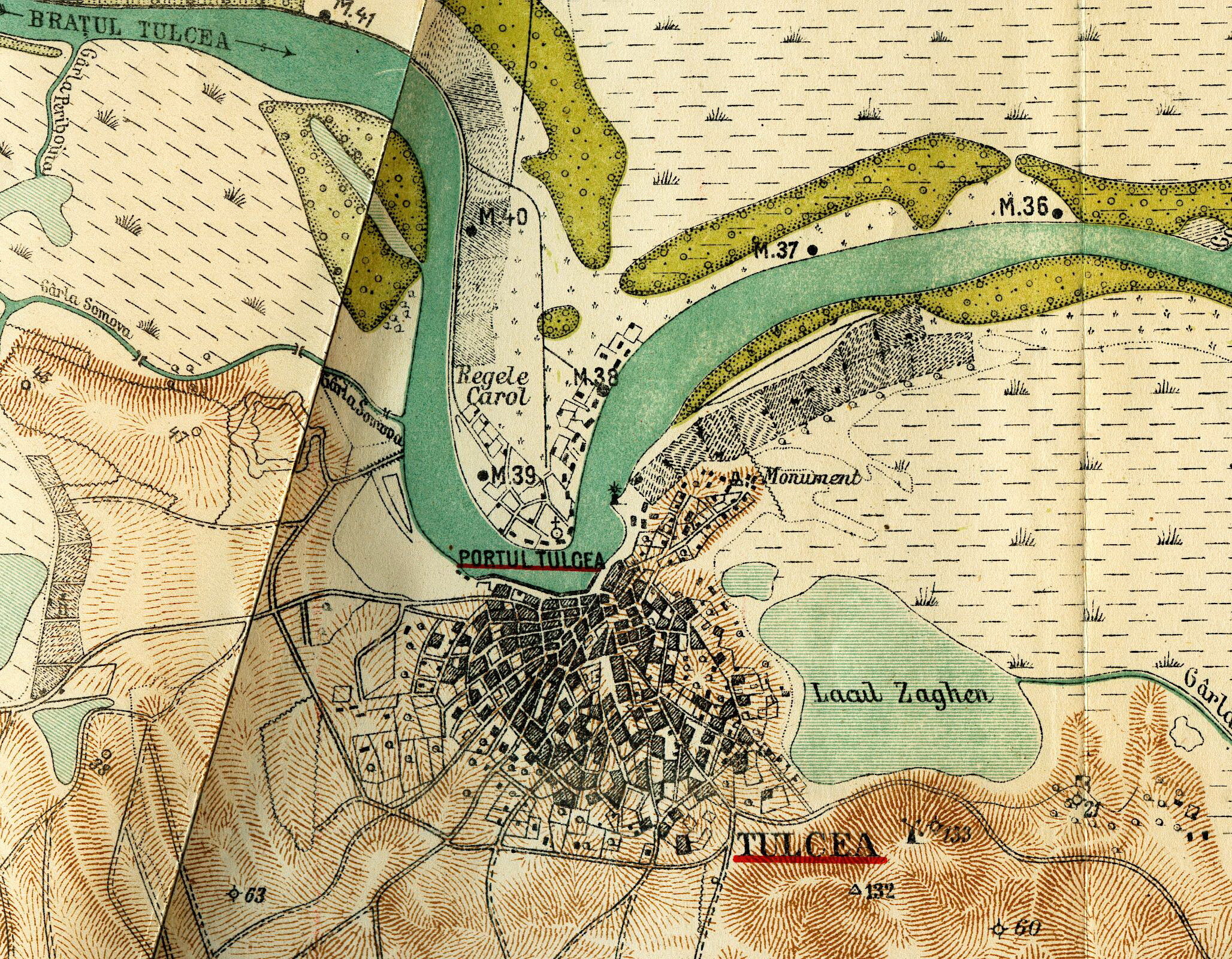
The port cities in which the C.E.D. has had an active presence are Sulina and Tulcea. Sulina has been fully developed through the contribution of the C.E.D. in terms of the configuration of the port, the urban infrastructure, the urban fabric and the local community. In Tulcea, the C.E.D. has had a notable presence in the development of the port infrastructure and urban structure.
In the cities of Brăila, Galați and Isaccea, C.E.D. has had an indirect contribution, referring, on the one hand, to specific activities that have led to the fluidization of the circulation on the Danube, have contributed to facilitating access to ports from the Black Sea and to lowering transport taxes, influencing the overall functioning of the river transport mechanism and, on the other hand, to minor, punctual interventions in the urban fabric or river transport infrastructure, which have not brought changes in the configuration of the urban structure or port infrastructure.
An analysis of the sea-river ports in the Braila - Sulina sector18 led to the conclusion that, during the period of the C.E.D.'s operation, 1856-1948, it is possible to detect varied typologies of configuration of these ports and their related infrastructure. What is the origin of this variety, in the context of unitary regulations at the level of the territory adjacent to the Danube?
We can list several factors that have differentiated the ports from each other: the importance of the river node in the European and national transport network, the size of the geographical basin served by the port in question and the international interest in the resources from that geographical basin, the investment of national institutions and international commissions in making river transport more efficient and in building port infrastructure, and the legislation on transport charges.
On the basis of these factors, it has been possible to crystallize a number of specific situations concerning the relationship between port development and the evolution of the port city, of which we are interested in the context of this article in the urban and architectural ones.
The evolution of the port is strictly linked to the urban development of the port city. Two historical conditions, The Peace of Adrianopole (1829) and the passage of the Romanian Lands under Russian protectorate (1831) led, in the second half of the 19th century, to the urban reconfiguration of many Romanian towns in the cross-border area. The city systematization projects carried out since the 1830s and the introduction of organic regulations had immediate effects, so that before the outbreak of the War of Independence, most of the towns on the Danube had already been transformed from an urban planning point of view, freed from the constraints of expansion caused by the existence of fortifications.
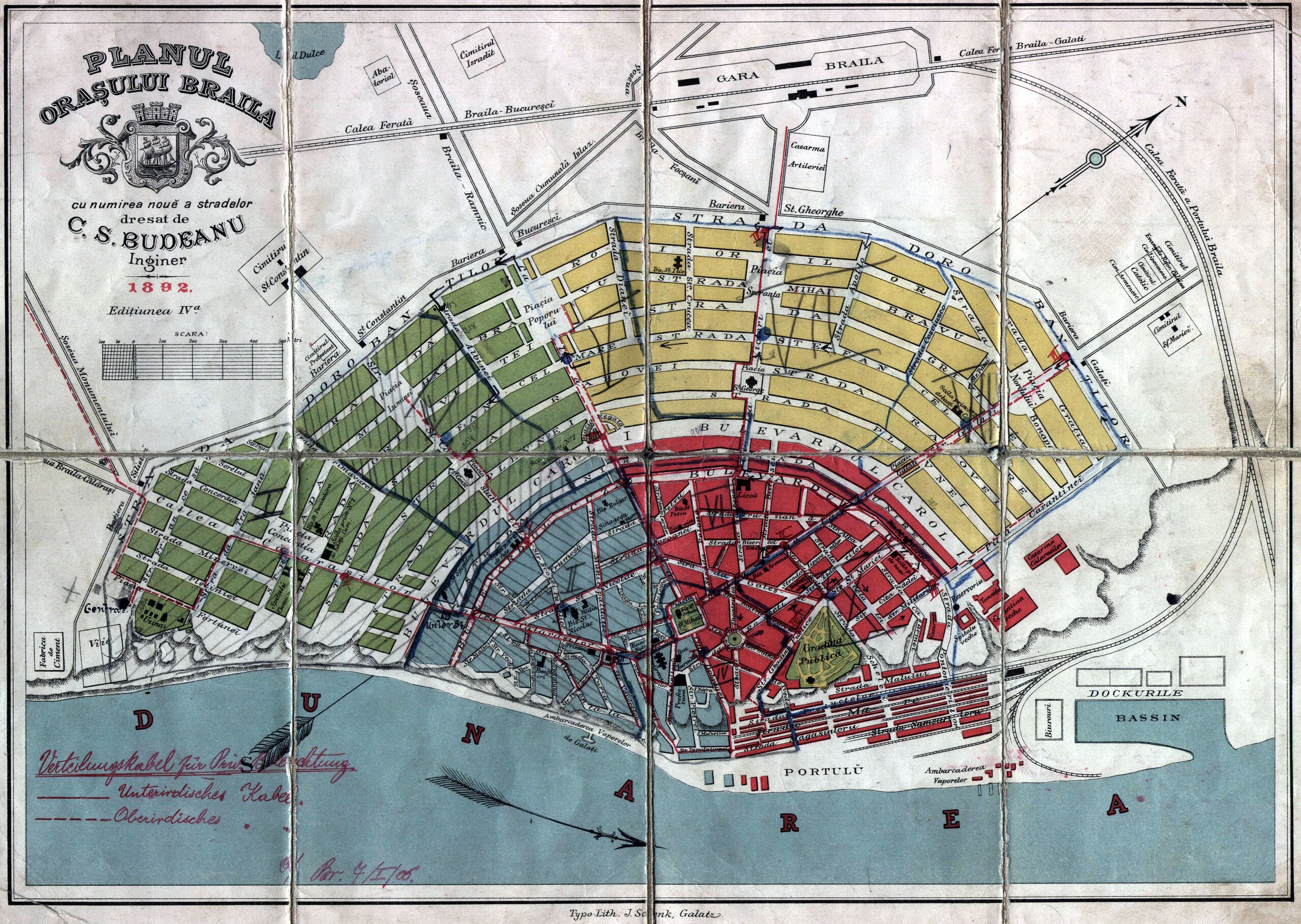
In Galați and Brăila, for example, systematization projects based on modern principles of spatial organization initiated by the Romanian Hydraulic Service led to the construction of port constructions adapted to the storage, transfer and transport needs of the Danube ports.
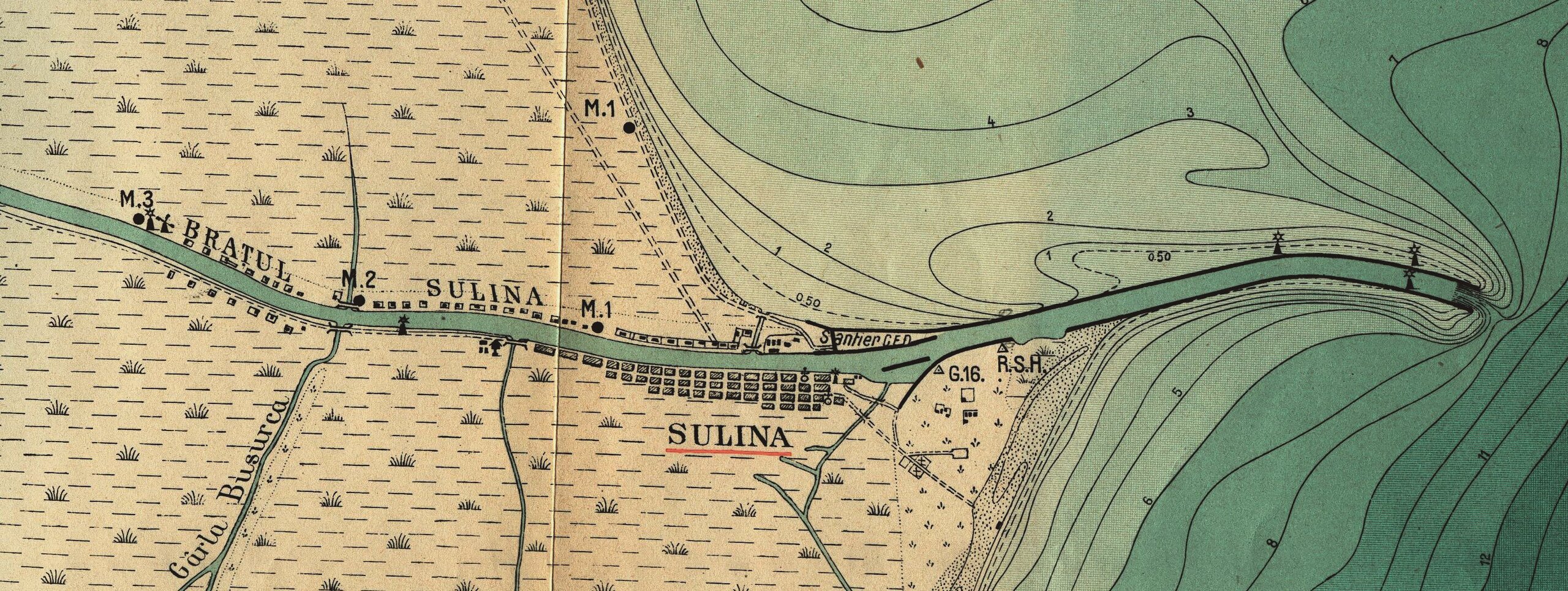
In the port of Sulina and on the Sulina navigation channel, the activity of the European Danube Commission has stimulated the creation of modern urban structures, suitable for a settlement that is constantly expanding and with a growing number of inhabitants due to the development of river trade. Sulina is practically a creation of the European Danube Commission.
The ports of Tulcea, Isaccea, the quayside port area of Galati and Braila have developed over time through successive port infrastructure expansion projects. The dock ports of Brăila and Galați and the port of Sulina were created on the basis of pre-established plans, large-scale projects that radically transformed the river transportation hub, inducing an organic development, as a necessity to increase storage and transportation capacity.
The spatial structure and organization of the ports is determined by the relationship created between the port facilities and the Danube. Thus, the ports developed along the Danube are linear ports, developed on one bank of the Danube (Tulcea, Isaccea) or on both banks of the Danube (Sulina). Galați and Brăila are gathered ports, where the main activities, mainly concentrated around the dock basin, form a core of the port area.
The length of the city waterfront occupied by port activities: in Galați and Brăila, port activities occupy half of the city waterfront, in Tulcea, two thirds, and in Sulina, the entire city waterfront.
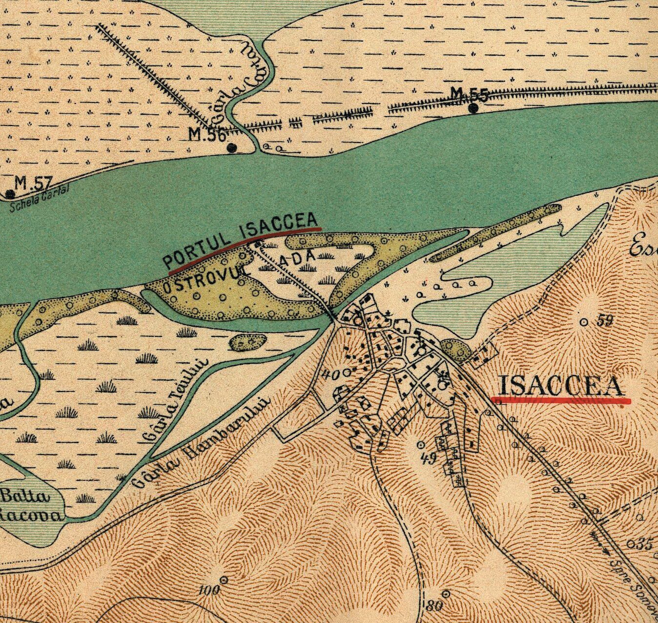
The urban relation of the port with the city and the central area. If, for example, the port of Isaccea is located at a significant distance from the city, in which case there is no direct relationship between the development of the port and the development of the city, the situation is different for the ports of Tulcea, Brăila, Galați, which are interconnected with the main areas of activity of the city and directly linked to the central area; in Sulina there is a relationship of dependence of the central area on the port activity and infrastructure.
The economic role of port activity in the city's economy can be (1) dominant, the city being mono-occupational, with river trade being predominant. In this category is included the port of Sulina, where the port represents the urban nucleus of the settlement. The central area of the city is identified with the Danube waterfront and the harbor area. All the main activities of the city are carried out around the harbor, the urban silhouette of the city is dominated by the existence of port facilities. The landmark buildings of the city are buildings serving the port activity. The harbor is developed linearly along the Danube, occupying the entire waterfront of the city. Port-related commercial activity is the main economic engine of the city. The port is primarily a transit hub where vessels from the Black Sea access the inland waterway, the role of transhipment of goods from the geographical basin of the city to the waterway being secondary; (2) main, the city is a poly-occupational type, where river trade is one of the dominant activities. The ports of Galati, Braila and Tulcea are included in this category. The port is one of the main engines of economic development of the city, in certain periods representing the core of the city's economy and the area that concentrates the main economic activities. The port is a nationally representative river traffic hub, its morpho-typological structure illustrating this. The port occupies a significant area of the city, being directly linked to the central area of the city by the traffic routes that connect the two and the commercial activities that extend along the main streets between the two areas. The port infrastructure contributes to the development of activities located adjacent to the port: areas with factories and manufacturing using raw materials transported by water, commercial areas with shops where goods transiting through the port are sold. The port equipment and facilities play a significant role in shaping the urban silhouette of the city, with the buildings related to port activities becoming symbolic buildings of the cities; (3) secondary, with the waterborne trade playing a minor role in the economic profile of the city. Isaccea port is included in this category. The port plays a secondary role in the network of Danube ports, and the commercial activities related to the port have a secondary contribution to the local and regional economy. The port infrastructure is less developed than in other types of ports, offering minimal facilities for the movement of ships. Port activities are located along the Danube waterfront, with a linear structure. According to the position of the port in relation to the city, Isaccea is a satellite port, located on the Danube bank at a considerable distance from the city. In this situation, the development of the port is independent of the city's expansion.
The structure and the components of the port, defining the services provided: passenger transport, transportation and storage of goods (Galați, Brăila, Sulina) or more restricted services, serving a smaller number of ships and with a smaller traffic capacity (Tulcea).
Port traffic and river trade
River trade activities in port cities reflect and fix the position of the city in the territorial hierarchy.
Thus, the ports of Braila and Galati are the only sea-river ports of Wallachia and Moldavia respectively, export ports for local products from the entire territory of the Principalities.
In Brăila, the effort to build a modern city on the ruins of the old Romanian and Ottoman fortress was made under the leadership of the paharnicnic Iancu Slătineanu, the founder of the present-day settlement. It called on a host of foreign engineers, Hartel, Andrei Kovacs, Major Arkudinski, Kuchnowsky, Louis Tallon, Thillaye, Wladimir de Blaremberg, the latter of whom was also sent to Odessa to study the construction of the dike. The city's great asset was the development from the outset of a "regularization" and urban development plan, which allowed the "European" appearance of Braila to take shape as early as 184019. "Braila is not the daughter of the Principality of Wallachia, but its mother". - The quote belongs to the great historian Nicolae Iorga20, who thus recognizes the strategic role that the Danube city had in the development of the Romanian Country, the end of the trade route from Transylvania to the Danube. We could say the same thing about Galati: it is the southern end of trade routes from Poland to the Danube (and the Black Sea) via the Siret.
Galații modernized somewhat less spectacularly under the reign of Mihail vodă Sturdza, in a sustained effort, each year seeing the quays extended and modern constructions in the port. We should not forget the active presence of Alexandru Ioan Cuza under the reign of Prince Grigore Alexandru Ghyka, in the decisive years before the Union of 185921.
After liberation from the Turks, Brăila (from 1836) and Galați (from 1839) enjoyed a prosperous porto-franco regime, which lasted until the mid-eighth decade of the 19th century. For both cities, therefore, a real economic, social and building-cultural growth followed, under the conditions of an ethnic mosaic structured on specific minorities in Brăila and Galati. It is significant that after the revolution of 1848, the maintenance of a border between Wallachia and Moldavia, primarily between Brăila and Galati, was felt by each province. In 1849, however, the taxes levied on the border between Moldavia and Wallachia, i.e. in the Brăila-Galați area, were abolished.
After 1859, despite the apparent opposition between the two cities, the need for them to work together was not rarely seen. The setting up of the European Commission of the Danube after 1856, and the establishment of its administrative headquarters in Galati may have slightly unbalanced the relations between the two cities, giving an advantage to the latter. It seems that the intention to transform the Danube into a free navigation route, from its source to its mouth, was not perfectly appropriated and assumed by the political authorities of the time. Competition was created and maintained between Braila and Galati, but also between them and other important ports of similar profile nearby (first Odessa, then, in special historical circumstances after the annexation of Dobrogea to the country, Constanta).
In the 80s and 90s of the 19th century, until the First World War, the balanced and seriously national-minded policy of the Liberals meant that Brăila, Galați and Constanța benefited from large investments in the development of docks, ports, silos, etc. Of course, many of these investments were made with money from Brăila, but the sense of maintaining the balance between the three major ports was obvious.
Thus, until 1914 in Galati, and until 1911 in Brăila, there was the biggest increase in trade in cereals and other goods, so that extensive building programmes were possible in Brăila and Galati, as well as substantial investment in what, at the time, political and economic factors called industrialization.
After the First World War, under the conditions of the Entire Romania, Braila and Galati go into decline in terms of their significance as commercial ports, as Europe changes. This created the conditions for the two cities to enter an area of economic, social and political calm, a phenomenon accentuated by the growing importance of the Black Sea port of Constanța.
After the Second World War, the decline of the two cities remains to a large extent similar, if not identical, with first of all the attempt of Galati to dominate the situation by its status of regional residence, coupled with large industrial investments, explained and explainable from a political point of view, which we do not insist on. After 1968 and the return to the county-based administrative-territorial organization, the balance seems to be re-established, with important industrial investments also in Brăila.
"We believe that after 1989 the situation in both cities showed that with the self-destruction of industry or its drastic decline (see the case of IUG Progresul Brăila and the steelworks of Combinatul Siderurgic Galați), the two cities will have to follow the path of rapprochement on all levels: economically, socially, culturally, the collaboration between the authorities, aiming to attract to the vast space between Brăila and Galați, whether it will be called BRAIGAL or GALBRAI, those European investments that will bring back to the forefront the two cities on the Danube. Clearly, the personality of each of the two large settlements will be evident in terms of buildings, culture and spirituality, but they will be united by the great and obvious economic interest that lies ahead of them".22
Located at a distance of less than 20 km, the two twin port-cities on the Danube belong to two historical provinces: Galati, in Southern Moldavia, and Braila, in Eastern Wallachia. Their symmetrical development has favored both competition and concord in terms of common needs, with economic increases or decreases over time. Today, the two cities are at a historic crossroads for the future of the two cities and the territory of the Lower Danube: cooperation for the development of an Integrated Urban System capable of meeting the multiple challenges of modern society and ensuring a significant growth of the component localities in the European urban competition. "Faced with the challenge of two development scenarios, either independently or within the framework of a joint project, Brăila and Galați must choose their path"23 A first step towards "reconciliation" is, of course, the construction of the bridge over the Danube at Brăila, which facilitates access to Galați. The Danube thus becomes a link, not a border.
The port of Tulcea was the main export point for the northern half of Dobrogea. There are a number of factors that made it difficult to develop the port of Tulcea and the river trade carried out through this port: the isolated position of the city in relation to the rest of the territory, the lack of communication routes that adequately linked the territory of Dobrogea and the left bank of the Danube, the lack of investment by the Ottoman and Romanian administrations in port infrastructure and the focus of the latter on seaports. As in the case of Galatiti, the modern development of Tulcea imposed a new territorial organization of Ottoman Dobrogea in the 19th century. The old ancient and medieval middle Dobrogean road through Bazargic, Qaraomer, Cobadin, Qarasu/Medgidia, Ester/Târgușor, Saqce/Isaccea, Oblucița ford, was abandoned in favor of the coastal road through Mangalia, Kustendje, Babadag, Tulcea.
The main products exported through the port of Tulcea in the period analyzed were cereals, timber, fish and fish products. It should be noted, however, that compared to the ports of Brăila and Galati, the quantities of exported products are very small.
The port of Isaccea is small, with a small geographical basin. The position of the city on the Isaccea Ostrov has made it difficult to develop the port infrastructure adjacent to the city, which remained minimal throughout the whole period of the C.E.D.
In the national hierarchy, the port of Isaccea can be categorized as a port of local importance.
As for the Sulina Port24 , the port infrastructure developed by the C.E.D. in the period 1856-1938 was adapted to the multiple functions that the port fulfilled: as the main customs point and as the headquarters of the workshops responsible for the maintenance of the navigable course of the Danube, as well as a port for transhipment of goods and for trade.
By comparing the traffic of the five sea-river ports under discussion25, on the basis of the revenues obtained by the port administrations from commercial taxes, the number of ships transiting the port, the quantity of products traded, a hierarchy can be established for the period of the EDC's activity: the port of Brăila is in first place, followed by the ports of Galați, Tulcea, Sulina and, in last place, at a considerable distance, the port of Isaccea.
The few historical milestones in the development of the sea-river port-cities in this article, by their fragmentary nature, open up a vast field of research, but we must not limit ourselves to the level of theory. Practice is killing us, time is running out and, before our very eyes, a huge heritage is being wasted or destroyed without the inventorying and enhancement of its value being a constant economic concern26. Moreover, in the context of the junction of the North Sea, the Baltic, the Western Mediterranean and the Black Sea through the inland navigation systems of Germany, the Netherlands, Belgium and France, research into the evolution of the Danube and adjacent Romanian maritime segment is a prospective contribution to overcoming stagnation and regression.
1 Water goddess and "mother" of the main rivers known to the Greeks.
2 Goddess and personification of the great waters that surrounded - in the conception of the ancient Greeks - the human world, and later personification of the Atlantic Ocean, considered the western boundary of the ancient world. Tethys and Oceanus are the parents of three thousand oceanids(nymphs) symbolizing all the waters of the earth.
3 Hesiod. Works, 1973, p. 35, biblioteca-digitală.ro.
4 Nicolae Densușianu, Prehistoric Dacia, Arhetip Publishing House 2002, p. 306
5 Aeschylus, The Prayers. The Persians. Seven against Thebes. Prometheus Chained, Univers Publishing House, 1982.
6 Nicolae Densușianu, Prehistoric Dacia, Arhetip Publishing House, 2002, pp. 403.
7 Ibid, pag. 424.
8 G. M. Cantacuzino, Lecture given in the studio of the Romanian Radiotelephone Broadcasting Society, August 24, 1933, in G. M. Cantacuzino, Izvoare și popasuri, Studii și conferințe, Editura Eminescu, 1977.
9 The study (coordinated by Marica Solomon) was the Romanian contribution to the European Union's INTERREG project on the development of a model for cooperation between maritime and island regions in the field of heritage protection, restoration and creative development, by identifying ways of capitalizing on the coastal cultural landscape and studying the optimal ways of intervening in transitional landscapes between port centers and coastal territorial systems.
10 In order to transform the provisions of the European Landscape Convention into working tools at the territorial level, it was considered that a necessary first step would be to clarify how to delimit a territorial area with which to operate: the landscape unit, "defined as a portion of territory with a certain coherence of the characteristics of its form, a coherence stabilized during its historical evolution as a place in which a human community, through its successive generations, lives and through this very fact and for this very reason modifies it" (Marica Solomon).
11 For the pre-modern period, the study was based on extensive documentation prepared by Bogdan Murgescu together with Simion Câlția and, for the modern period, on material prepared by Nicolae Lascu. For the heritage of the port cities, the study benefited from the contributions of Ralucăi Iosipescu and Sergiu Iosipescu.
12 Nicolae Lascu, The Danube-Black Sea territorial system in the modern era, 'Urbanismul - Serie Nouă', 5-6/2010, pp. 38-40.
13 Raluca Iosipescu, Sergiu Iosipescu, Orașe-porturi la Dunărea de Jos and la Marea Neagră, in "Urbanismul - Serie Nouă", 5-6/2010, 5-6/2010, pp. 41-45.
14 Ștefan Stanciu, Alexandru Duță, Tratate, convenții și alte documente referitoare la regimul navigației pe Danânrea Maritimă, 2009, p. 20-21.
15 "For Russia, the Danube has always been the way to save the Empire! It is also the symbol of the 'road to the West', of its historical tendency to expand its Tsarist policies of the 18th century." Charlotte Rasmussen, Freedom of the Danube, Current History, XII (January 1947).
16 Dinu Giurescu, Istoria României in data, 2010, p. 510.
17 Ibid, p. 109.
18 Ana Maria Petrescu, The European Danube Commission and the Romanian ports of the Maritime Danube. 1856-1948, doctoral thesis 2020, supervisor: prof. dr. arh. Prof. Dr. Anca Brătuleanu.
19 Raluca Iosipescu, Sergiu Iosipescu, Orașe-porturi la Dunărea de Jos și la Marea Neagră, in "Urbanismul - Serie Nouă", nr. 5-6/2010, pp. 41-45.
20 Nicolae Iorga, Chestiunea Dunării (History of Eastern Europe in relation to this question). Lecții tenute la Școala de Războiu tipărite după nottele stenografice ale dlui H. Stahl, pentru folosul elevilor săi, Vălenii de Munte, Editura Societății Neamul Românesc, 1913, https://www.scribd.com/doc/312666165/N-Iorga-Chestiunea-Dunarii-pdf.
21 Under the reign of Cuza, on 18 November 1863, the French-inspired Port Law was passed, which made a decisive contribution to the organization of the Romanian towns on the Lower Danube. The law was amended in 1904, so that it can be said to have presided over most of the stage of Romanian port development before the First World War.
22 Ionel Cândea, Brăila-Galați or Galați-Brăila - Zone of historical convergence, in "Urbanismul - Serie Nouă" nr. 12-13/2012, p. 73-75.
23 Costel Drăgan, Scenarii de dezvoltare a sistemului urban Brăila-Galați, in "Urbanismul - Serie Nouă" nr. 12-13/2012, p. 77.
24 For more on Sulina, read Anca Filip, Sulina. Povestea unui tărâm aparte, p. 106-131; Anca Galiceanu, Farul de la capătul Dunării, p. 158-169, in Arhitectura nr. 3-4/2022.
25 Ana Maria Petrescu, The European Commission of the Danube and the Romanian ports of the Maritime Danube. 1856-1948, Ph.D. thesis 2020. Supervisor: prof. dr. arh. Prof. Dr. Anca Brătuleanu.
26 Raluca Iosipescu, Sergiu Iosipescu, Orașe-porturi la Dunărea de Jos și la Marea Neagră, in "Urbanismul Serie-Nouveă", nr. 5-6/2010, pp. 41-45.
Victor Kernbach, Dicționar de mitologie generale, Editura Științifică și Enciclopedică, Bucharest, 1989
Grigore Antipa, Dunărea si problemele ei științifice, economice și politice, Tipo Moldova, Dr. Gr. Antipa, 2012, 191 pages (1921)
Nicolae Iorga, Chestiunea Dunării (History of Eastern Europe in connection with this question). Lecții tenute la Școala de Războiu tipărite după nottele stenografice ale d-lui H. Stahl, pentru folosul elevilor săi, Vălenii de Munte, Editura Societății Neamul românesc, 1913 - https://www.scribd.com/doc/312666165/N-Iorga-Chestiunea-Dunarii-pdf
G. M. Cantacuzino, Conferință tenută în studioul Societății de difuziune radiotelefonică din România, August 24, 1933, in G. M. Cantacuzino, Izvoare și popasuri, Studii și conferințe, Editura Eminescu, 1977.
Ana Maria Petrescu, European Commission of the Danube and the Romanian Ports of the Maritime Danube. 1856-1948, PhD (supervisor: prof. dr. arh. dr. Anca Brătuleanu)
Constantin Ardeleanu, The European Commission of the Danube 1856-1948, An Experiment in International Administration, volume 27, Balkan Studies Library, brill.com/bsl, https://library.oapen.org/bitstream/handle/
Nicolae Lascu, Irina Tulbure, Gabriel Panasiu, Studiul istoric de fundamentare, for Actualizare PUG și strategia de dezvoltare spațială a municipiuluiGalați, UAUIM-CCPEC contract, 2010 (unpublished work)
_Tulcea%20wikimedia--15691-xl.jpg)


-topaz-denoise-enhance-sharpen--15883-m.jpg)